Tuesday, August 3, 2021

Traveling South - Alaska and BC in the rearview mirror

Location: Port Angeles, Washington

We have started our journey south.  We cruised Southeast Alaska until mid-July, then on July 20th we crossed the border, cleared into Canada in Prince Rupert and spent 10 days transiting through BC.  We're now in Washington, planning to head west out of Juan de Fuca Strait and south down the coast towards Oregon and California.

Seabiscuit at the dock amongst the seiners, Casey Moran Harbor, Ketchikan, Alaska


Friday, July 9, 2021 – Petersburg, Alaska to Wrangell, Alaska (40 nm, 6 hours):  Our last day in Petersburg.  We started with breakfast at the Salty Pantry, bought a few groceries and checked out of the marina.  We left the dock at 13:15 to catch the current down the Wrangell Narrows.  It was foggy and raining so we ran the radar.  After we got down to Scow Bay, a wide spot in the narrows, Dave went down to the engine room to check the voltage, amperage and temperature readings on the alternators.  All were operating within normal parameters which was good news.  

Approaching an area with multiple aids to navigation in Wrangell Narrows
 
As reported in previous blogs, the Wrangell Narrows is a 21 nautical mile waterway that connects Frederick Sound on the north with Sumner Strait on the south.  There are over 60 channel markers/aids to navigation and 5 range markers.  Currents can run over 4 knots in the narrows, but if you time it right, from the north you can ride the end of the flood tide south to the point where the currents meet, then ride the ebb tide out of the south end. 


Why fly or swim when you can go on a log ride. Seagulls on a log,
Sumner Strait, South of Wrangell Narrows

We exited the south end of the narrows, turned east and crossed Sumner Strait towards Wrangell.  As we got  closer to Wrangell, the water color changed from blue-grey to greenish-brown and then to muddy brown, with very distinct boundaries between the color bands.  The Stikine River, which starts in British Columbia, drains into Southeast Alaska and forms a delta just north of Wrangell.  The mixing of the water from the river delta into Sumner Strait creates the color changes.  If you look at the satellite version of the map above, you can see the color changes and the mixing of the sea water with the river delta.

As we approached Wrangell, we called the harbormaster on the VHF to ask if there was space available at the Reliance Dock in the main harbor near downtown.  He said there was so we pulled in and side-tied to the dock ~19:30.  We walked up to the Stikine Inn for supper then settled in for the night.  The downtown harbor in Wrangell is very different from the Petersburg harbors.  The Petersburg harbors are full of seine fishing boats; the Wrangell downtown harbor is full of small sportfishing boats.

Saturday morning we watched a group of jet-skiers pull away from the dock, get fuel and head out of the harbor.  They had spent yesterday at the Anan Bear Observatory and were going to Angoon today.


Jet-skies moored along the dock in the Wrangell Harbor.

The jet-skiers leaving Wrangell Saturday morning.  They were heading to Angoon.

We spent Saturday morning doing projects and chores.  Saturday afternoon we walked through town and out to Petroglyph State Historic Site which includes a boardwalk explaining the history of the petroglyphs and replicas that can be used to make rubbings.  We explored Petroglyph Beach but only managed to find one original petroglpyph.

View from the Petroglyph Park Boardwalk - Looking across Zimovia Strait at Elephant Nose Point on Woronkofski Island

A replica of a petroglyph at  Petroglyph State Historic Site, Wrangell, Alaska

An original petroglyph on Petroglyph Beach.  There are over 40 but we only managed to find this one.

Chain saw carvings in Wrangell

Sunday, July 11, 2021 – Wrangell, Alaska to Thoms Place, Alaska (25 nm, 4 hours): We left the dock at 7:00 this morning to time our passage through the narrows in Zimovia Strait at slack water.  It was tricky planning as the currents ebb and flood both ways around two of the islands we would pass by along the way meaning we would have the current against us at the beginning of the voyage and with us later.  We had light rain with winds 10-15 knots and no seas.  We cruised through the narrows with no issues, dropped off the shrimp trap outside the entrance to Thoms Place, dropped off the crab trap inside the bay and anchored up on the west side of the bay out of the wind.  Our project of the day was to re-caulk the galley counters.  We did an early evening bear scan and spotted a mother bear and two cubs on the shore at the head of the bay.  

Monday, July 12, 2021 – Thoms Place, Alaska to Thorne Bay, Alaska (38 nm, 5.8 hours): We heaved anchor at 5:30 this morning to catch the ebb tide going south and to get to the narrows at Thorne Bay Inlet near slack water.  The crab trap was empty but we were pleasantly surprised that the prawn trap had 21 large prawns in it.  We tied up to the dock in Thorne Bay late morning and walked up to the cafe for lunch.  For our afternoon adventure we walked up to The Claw, the largest log-handling grapple in the world and a symbol of Thorne Bay's logging history.

Today was our granddaughter Maggie's 10th birthday and the 10th anniversary of our purchase of Seabiscuit. 

Approaching the Thorne Bay Marina

B under The Claw, Thorne Bay, Alaska

We spent Tuesday morning doing boat chores.  Tuesday afternoon we hiked up to The Lookout which overlooks the town and the bay.

The view from The Lookout, Thorne Bay, Alaska

Wednesday, July 14, 2021 – Thorne Bay, Alaska to Ketchikan, Alaska (40 nm, 6 hours): We woke up this morning to the noise of a crow eating bait out of the shrimp trap and "stomping" around on deck.  We left the dock at 6:00 to catch the ebb current flowing south down Clarence Strait.  Our first stop in Ketchikan was the fuel dock where we topped up our two forward tanks with 1150 gallons of diesel.  We had done some research on fuel pricing and Alaska was cheaper than Washington, Oregon and California so we decided to fill up before going further south.

There was space available at the Casey Moran Harbor (City Float) near downtown so we moored there.  We had some local knowledge that there was good shrimping from the docks and we put our shrimp trap over the side in about 140 feet of water.  We have been having issues with our VHF radio that we weren't able to fix so we walked up to the marine store and bought a new one.  We hooked up the power and the antenna and did a quick radio check before completing the installation.  The profile was higher than our previous model and we had to modify the panel in the console but other than that it was plug and play.  

Our new VHF radio Standard Horizon 1800

We pulled up our shrimp trap Thursday morning and were happy to have 30 shrimp inside; when we pulled it up on Friday we had 14 inside.  We spent the morning doing boat chores then walked up the hill and had lunch at a local bakery. 

B pulling up the prawn trap, Casey Moran Harbor, Ketchikan, Alaska

Success! 30 prawns inside the trap on Thursday and 14 more on Friday.

After lunch, we walked up to the Safeway for groceries.  Late afternoon, Darlene and her dog Moxie stopped by the boat for a visit.  Darlene (KL0YC), Floyd (WL7CUO) and Moxie were in Ketchikan for doctor and vet appointments and for re-provisioning.  Darlene is Northern net control for the Great Northern Boater's Net, HAM Radio 3870 KHz, and we have been checking in with her every morning since we arrived in Alaska.  The northern portion of the net runs from 6:30 to 7:00 Alaska Daylight time during the summers and the southern portion runs from 7:00 to 7:30 Alaska time year-round.

Friday, July 16, 2021 – Ketchikan, Alaska to Dora Bay, Alaska (28 nm, 4 hours):  We were planning to visit Floyd and Darlene at their cabin in Dora Bay and since they were in Ketchikan, we made arrangements for Darlene, Moxie and their supplies to ride over with us on the boat rather than on the float plane.  We spent the morning loading boxes of groceries, supplies and household goods.  Floyd was scheduled to fly to their cabin in Dora Bay but, because of the fog, his flight was cancelled and he rode along with us.  We got all of their stuff loaded and pulled away from the dock at 13:00 for the 28 mile voyage up the Tongass Narrows and across Clarence Strait to Dora Bay.

Cruising from Ketchikan to Dora Bay, Floyd and Moxie and boxes of good in the saloon

Cruising from Ketchikan to Dora Bay, Darlene and Dave in the pilot house

About 17:00 we tied up at a neighbor's dock, near Floyd and Darlene's place, and got busy.  We launched the dinghy and Dave took Floyd, Darlene and Moxie over to their beach, then he came back followed by Floyd in their skiff.  We transferred all the boxes from the boat to the dock to the skiff then went back to their beach to unload onto Max, their garden tractor.  Max carried the boxes up the beach to the cabin stairs and then we carried the boxes up the stairs.  By the time we finished everyone was tired.  We left Darlene and Floyd so that they could get the perishables stowed in the refrigerator and freezer and dinghied back to the boat for supper.

Seabiscuit at the neighbor's dock in Dora Bay.  Darlene and Floyd's boxes are stacked along the dock rail ready to be loaded onto their skiff.

Floyd, Dave and Darlene unloading boxes from the skiff to Max.

We spent most of Saturday with Darlene and Floyd.  We started with fresh roasted brewed coffee then Darlene taught me how to make a cheese ball using her smoked salmon plus fresh cilantro from her garden and garlic.  We had the cheese ball with crackers and pasta salad with a special olive salad mix for lunch then we went back to the boat for our afternoon nap.  We went back to the cabin late afternoon for more visiting then Darlene cooked us a delicious supper:  broiled venison back-strap with mushroom sauce, corn-on-the-cob and sea asparagus, something we hadn't tried before.  


Darlene and Moxie tuning up the HAM radio so she can check us all into the Bush Net

After supper, we walked outside to check out Darlene's garden and into the woods to search for coralroot orchids and step-on-me orchids.  We came back to the cabin and Darlene checked all four of us into the Bush Net, a nightly HAM radio net that operates from 20:00 - 20:15 Alaska Time on 7093 KHz and from 20:15 - 20:30 on 3920 KHz.  This is a controlled social net that we regularly check into and all are welcome to participate.  After that Dave and I dinghied back to the boat and got everything ready for our departure in the morning.


Sea asparagus on the beach near the neighbor's dock. 
We both liked it so we picked some before leaving in the morning.

Frog Mountain in Dora Bay

Sunday, July 18, 2021 – Dora Bay, Alaska to Metlakatla, Alaska (29 nm, 4 hours):  After checking into the Boater's Net with Darlene, we went ashore and picked some sea asparagus then got underway.  Darlene, Floyd and Moxie waved goodbye from their beach as we cruised by.  There were lots of sport fishing boats out around the islands near the entrance to Cholmondeley Sound on the west side of Clarence Strait and there was a seine fishery open so there were a lot of seiners on the east side of the Strait near Gravina Island.  

We pulled into the harbor at Metlakatla and were greeted by a Covid Tracker as we tied up to the dock.  She took down our names and information and asked where we had come from.  The community is still under lock down status and masks are required indoors.

Metlakatla is the only Indian Reservation in the state of Alaska and has a very interesting history as described in the linked article.  We settled in and had lunch then went for a walk around the community.

B near the Metlakatla Sign

Totem Pole near the Wil la mootk Counseling Center

Petroglyph carvings near the Wil la mootk Counseling Center 

Dave picking salmon berries in Metlakatla

Monday, July 19, 2021 – Metlakatla, Alaska to Kanagunut Island (56 nm, 8 hours): It was bright and sunny when we left the harbor this morning.  There was a gill net fishery open today so we stayed away from the coast of Annette Island to avoid the fishing nets.  We stopped to fish south of Duke Island. I caught and released a small rock fish then we moved south east to Club Rocks where we caught and released one small rock fish and one very small ling cod.  No keepers but at least we didn't get skunked.  

We pulled into the south entrance of Lincoln Channel and anchored up in a cove on Kanagunut Island.  There was a small work float nearby and several gill netters came in and tied up to it later in the evening.  We noticed that the freezer temperature was rising so we defrosted it thinking that the thermostat bulb might be frozen and not triggering the compressor.  That didn't work but it was late and we decided save the trouble shooting for tomorrow.

Tuesday, July 20, 2021 – Kanagunut Island, Alaska to North Kelp Passage, BC via Prince Rupert (51 nm, 7 hours):  The US / Canada border was still closed to non-essential travel when we were ready to cross the border and travel south from Alaska back to the lower 48 states.  The same rules applied as when we transitted from south to north – no stopping for fun, etc.  

Alaska in the rearview mirror

We crossed Dixon Entrance and put up our Canada and quarantine flags then made our way to the north entrance of Venn Passage and wound our way down to Prince Rupert.  At the customs dock, we cleared into Canada, submitted our transit plan to CBSA then continued south to North Kelp Passage where we anchored up for the night.  

We did some more troubleshooting on the freezer - removed all of the food (of course the freezer was full because we had just stocked up in Ketchikan) and disassembled the cold plate and the thermostat.  We have a spare thermostat on board but the wiring/electrical connections are very different than the one installed.  Dave figured out a way to by-pass the thermostat with a jumper so that we could run the compressor at low speed and he rigged up a fan to cool the compressor so at least we have a temporary fix until we can get the parts for a real fix.

The wiring to the existing thermostat control

Our spare thermostat.  You can see the difference in the electrical connection types.

Our temporary fix for the freezer, a jumper to turn on the compressor and a portable fan to cool it.


Sunset at North Kelp Passage

Wednesday, July 21, 2021 – North Kelp to Coghlan Anchorage (57 nm, 8.5 hours): Anchor up at 7:15 this morning for the run down Grenville Channel.  It was rainy and overcast for most of the day but we did see a little sun and some spots of blue sky.  We anchored up at Coghlan Anchorage about 16:00 and settled in for the night.

Dave grilling tri-tip for supper, Coghlan Anchorage, BC

Thursday, July 22, 2021 – Coghlan Anchorage to Bottleneck Inlet (57 nm, 8.3 hours):  Anchor up at 6:30 this morning.  Overcast and light rain and an uneventful voyage.  We anchored up in Bottleneck Inlet ~15:30 and settled in for the night.


View from the pilot house as we travel south down the inside passage

Friday, July 23, 2021 – Bottleneck Inlet to Fancy Cove (57 nm, 8.3 hours): Anchor up at 7:30 this morning.  It was overcast and rainy and the wind was blowing.  We were planning to travel south down Finlayson Channel to Seaforth Channel via Millbanke Sound but we saw Captain Kidd, a boat we have been travelling with, turn into Jackson Passage, a protected scenic channel between Finlayson and Mathieson Channels.  We followed them through then also used Reid Passage to avoid the wind and seas in Millbanke Sound.  Although slightly longer, by taking this route we avoided the exposure to the ocean swells, wind and seas in Millbanke Sound at the western end of Seaforth Channel.  We anchored up for the night in Fancy Cove on the south shore of Lama Passage.

Captain Kidd at anchor in Fancy Cove. 
We followed them through Venn Passage, north of Prince Rupert, to the Customs dock and we have been sharing anchorages every night since then.

Saturday, July 24, 2021 – Fancy Cove to Millbrook Cove (52 nm, 7.5 hours):  It was raining this morning.  Captain Kidd left the anchorage ~6:00; we had our coffee and breakfast then left ~7:30.  They were headed to Fury Cove for the night.  We decided to go further south and we anchored up in Millbrook Cove.


Logs, driftwood and flotsam along the shores of the islands that we wove through on our way in to Millbrook Cove.

Sunday, July 25, 2021 – Millbrook Cove to Spout Island Cove (64 nm, 9 hours): It was raining again this morning but the winds were light and there were no wind waves.  We left Millbrook Cove at 7:30 and headed south around Cape Caution.

The marker at Cape Caution

Other than dodging logs and flotsam along the way, the voyage was uneventful and we anchored up in Spout Island Cove ~15:30.

The Curve of Time anchored in Spout Island Cove. 
Built in 1959 in Holland, she is a North Sea Trawler named after a Muriel Wylie Blanchet memoir about travelling the BC coast in a boat with her five children (an excellent read if you can find it).  Previously named "Moby Dick" and owned by Green Peace, she now does charter kayak and eco-tours along the BC coast.

 Monday, July 26, 2021– Spout Island Cove to Gowlland Harbor North (72 nm, 9 hours): We had an easy morning this morning, doing boat chores and watching the activity in the cove.  It started out foggy, but by the time we were ready to leave at 11:00, the fog had mostly burnt off.  The late departure was so that we could make the run down Johnstone Strait and arrive at Seymour Narrows close to slack water at 20:15.  We had the current against us for the first couple of hours, then the tide changed and we had it with us for the rest of the day.  Our speed was all over the place, from 6 knots when we had the current against us in Blackney Passage to over 12 knots in Johnstone Strait where the current was running 5 knots or more.  

A tug with an empty log barge traveling west in Johnstone Strait

We picked up enough speed along the way to arrive at the narrows an hour before slack water.  Maximum flood today was 13.6 knots at 16:48, so by using the 50/90 rule of thumb to calculate the speed of the current an hour before slack, we figured it was still running at over 6.5 knots (the 50/90 Rule gives you “… the SPEED OF THE CURRENT at the end of each hour" in a 6 hour tide cycle. Counting from slack, the current will flow at 50% of its maximum speed at the end of the first hour, 90% at the end of the second hour and full 100% or maximum speed at the end of the third hour and then back to zero with the same steps.  The full rule should be stated as 0/50/90/100/90/50/0).

There were two tugs with a log tow waiting just north of the narrows for slack water.  We watched one of the tugs go through (no logs in tow) with no issues.  We couldn't see any angry, roiling water in the middle of the narrows so we decided it was okay to go through early.  Our calculations were pretty accurate and we went through with our speed over ground (SOG) over 12 knots.  Other than some swirling in the currents as we rounded Race Point south of the narrows, we didn't have any issues.  We made our way south down Discovery Channel and into Gowlland Harbor North where we anchored for the night.

Tuesday, July 27, 2021 – Gowlland Harbor North to Codfish Bay (59 nm, 8 hours):  Anchor up at 6:30 this morning to catch the last of the flood flowing south down Discovery Passage and into the Strait of Georgia.  The currents flow both ways around Vancouver Island and meet south of Cape Mudge and we were able to time our voyage to get a push from the current for most of the day.  We anchored up mid-afternoon in Codfish Bay on the east side of Jedediah Island.  It was a nice sunny afternoon so we stored some of our rain gear and laid out the shrimp and crab traps and lines to dry.

Wednesday, July 28, 2021 – Codfish Bay to Clam Bay (38 nm, 5 hours):  A short voyage today down towards Nanaimo, through Dodd Narrows and into the Gulf Islands.  It was great to see the sun out again today and we had an uneventful voyage.  We anchored up in Clam Bay between Thetis and Penelakut Islands, settled in and did some outside chores.  The anchorage was busy and by late evening there were 20 other boats anchored in the area. 

Thursday, July 29, 2021 – Clam Bay, BC to Roche Harbor, WA (30 nm, 4.5 hours):  Another short run today.  Anchor up at 8:30 for a nice cruise across the border to Roche Harbor.  We used the CBP Roam App to clear customs into the U.S.  We came through the northern entrance to Roche Harbor ~12:30 and found a zoo inside.  There were boats of all sizes anchored throughout the harbor.  The VHF was buzzing with boats calling the harbor master to get a slip or to get on the waiting list for a slip.  Kayakers were paddling around and people in dinghies and skiffs were checking their crab traps.  We called the harbormaster to get on the waiting list for a slip.  He told us that the chances for today were slim so we anchored up in the harbor amongst the crowd and settled in.  We spent the afternoon doing a few light chores and watching the activities in the harbor.

M/V Phecal Phreak, the Roche Harbor pump-out boat, is very busy during the summer season.

Friday morning we had our breakfast and coffee, checked into the southern portion of the Boater's Net then called the Harbormaster on the VHF to get on the waiting list for a slip.  Instead of a reservation system, they start a new wait list each morning, with boats calling in via the VHF radio starting at 8:30;  there were a few boats that tried to call in before then but the harbor didn't respond until the 8:30 bell had rung.  Then, as boats leave the slips, the harbormaster phones each boat and gives you your slip assignment.  Check out time is noon so many slips don't become available until then.  We had some time to kill, so Dave suited up in his dive gear and went into the water to check the anodes, all good, and to scrape barnacles off the hull and props.  We got a call from the harbormaster at 12:30 saying that our slip was available so we heaved anchor and moved into the marina.  We had lunch at the cafe and took a walk around the marina, then got a few groceries, did some laundry and watched the activities around the docks.

Saturday morning a rain shower moved through the area which everyone was glad to see.  We washed some of the salt off the boat, did boat chores and set our crab and shrimp traps, lines, buoys and bait bags up for sale on the swim platform.  Early afternoon we went for a walk in the San Juan Island Sculpture Park.  Later than afternoon somebody stopped by and bought our traps.  We had supper at McMillin's then called it a night.

A sculpture in the San Juan Island Sculpture Garden

Wild flowers in bloom, San Juan Island Sculpture Garden


Sunday, August 1, 2021 - Roche Harbor to Port Angeles (37 nm, 5 hours):  Sunday morning we watched the boats around us start to begin to prepare to initiate to leave the marina.  Check out wasn't until noon (did I mention that already?) and two of the boats nearby planned to leave at 11:59.  We were blocked into our slip and couldn't leave until the boat in front of us left.  We didn't see them stir until after 10:00, then watched them take out the trash, go to the grocery, fill water, get their tanks pumped out by the Phecal Phreak and take the dog for a walk.  They fired their engines up at 11:45 and got away from the dock 5 minutes before noon.  We followed them out, turned south down Mosquito Pass and into Haro Strait.  We turned into the Strait of Juan de Fuca where we had the eb current flowing from east to west and the wind blowing 20 - 25 knots from the west, so we had the classic ebb current opposing the wind and short steeps waves.  Once we got inside the Port Angeles Harbor, Ediz Hook protected us from the seas.  We tied up alongside the guest dock in the Port Angeles Boat Haven then walked downtown for supper.  

The Lime Kiln Lighthouse on the west side of San Juan Island

We decided to stay in Port Angeles for a few days to wait for the wind to calm down in the Strait of Juan de Fuca before heading west and then south around the corner into the Pacific  We've been taking advantage of being in town and doing our normal town activities.

The MV Kalakala mural, downtown Port Angeles

Until Next Time…

Thursday, July 8, 2021

Southeast Alaska - Hoonah to Petersburg

Location:  Petersburg, Alaska

At the end of the last blog, we were in Hoonah, a town we always enjoy visiting.  From there, we anchored a few nights before cruising into Juneau, then anchored a few more nights before coming into Petersburg.

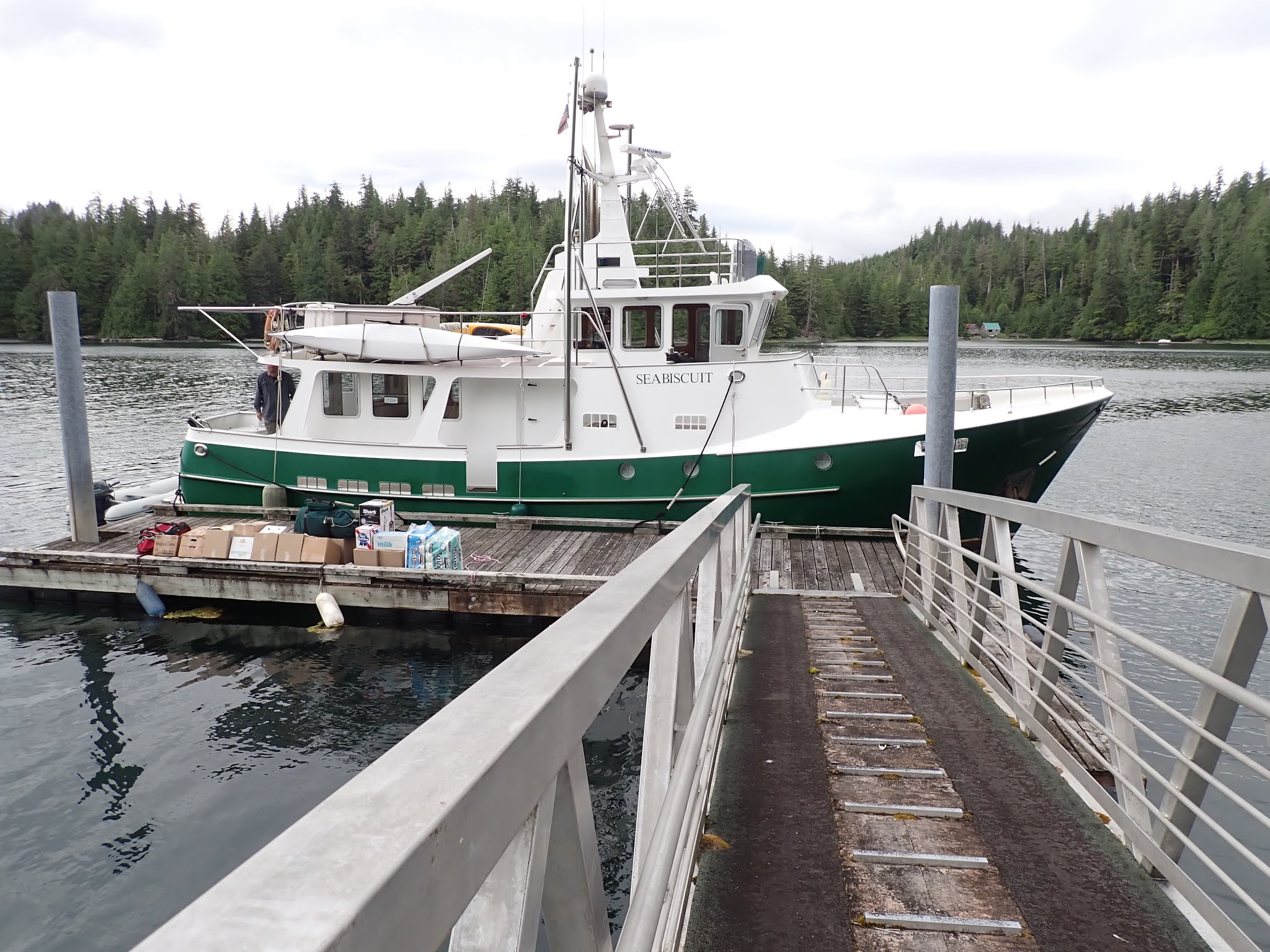
Seabiscuit at anchor, Dundas Bay, North Arm


June 12, 2021, Saturday - Hoonah to Dundas Bay, North Arm (46 nm, 7 hours):  We did a few chores before leaving the Hoonah transient dock this morning at 9:45.  We cruised out to the crab trap hoping for a big haul, but there was nothing inside.  The seas and the winds were very calm, like a mill pond, which I always find eerie, especially with the white cloudy colorless sky; it's like you're drifting along in nowhere land.  We stopped to fish on the east side of Lemesurier Island but didn't catch anything.  

Dave preparing bait so we could stop and fish on our way to Dundas Bay

B picking up the crab trap - empty again

We saw a humpback whale, sea lions and sea otters along the way.  We turned north into Dundas Bay, watching the shoreline for wildlife as we cruised along.  We finally spotted a black bear feeding in the grass at the head of the North Arm just as we were getting ready to drop the anchor.  Another black bear came out later in the evening and we watched it graze along the creek while the other one dug clams along the shore.

Black bear digging for clams along the shore at Dundas Bay, North Arm

Sunday we launched the dinghy and went out looking for wildlife.  We spotted a mother brown bear and a small cub on the west shore and a large black bear on the east shore, plus a few sea otters near a rock close to our anchorage.  


B driving Dave around in the dinghy, Dundas Bay 

The mountains surrounding Dundas Bay, North Arm

Sea otters swimming near our anchorage

For our afternoon project, we cleaned the galley fan and housing.  They were filthy and full of grease and we found an old mud dauber nest inside the cover... ugh!

The galley fan and housing - before cleaning

B cleaning the galley fan and housing

The galley fan and housing - after cleaning

The rest of the afternoon was spent unlaxing and enjoying the views and wildlife around the bay.

June 14, 2021, Monday - Dundas Bay to Swanson Harbor (55 nm, 8 hours):  Anchor up at 7:00 this morning; we spotted a bear on our way out of the bay.  We had the current going with us as we cruised south out of Dundas Bay, then had it in our face once we turned east into Icy Strait.  It finally changed and was with us again as we passed along the north side of Lemesurier Island.  We stopped to fish in two different spots along the way but didn't have any luck.  We dropped off the shrimp trap outside the entrance to Swanson Harbor, then dropped off the crab trap and were anchored up by 15:30.  It was a beautiful sunny afternoon and we sat outside on the stern and soaked up the warmth.

Dave comtemplating life as we cruise from Dundas Bay to Swanson Harbor

June 15, 2021, Tuesday - Swanson Harbor to Juneau, Harris Harbor (60 nm, 9 hours):  This morning was just the opposite of yesterday afternoon.  The wind was blowing in the high teens, it was raining and we had an ebb chop as we left the harbor.  The crab trap was empty; the shrimp trap had one starfish and two sea urchins in it.  We bumped our way across Chatham Strait toward Auke Bay.  The wind and the seas died down as we made our turn around Point Retreat at the northwest tip of the Mansfield Peninsula.  We got to Auke Bay about 13:30, but six Grand Banks boats had arrived about 30 minutes ahead of us and filled up all the available dock space.  We could see them looking for slips in Statter Harbor, then come around to the outside of the breakwater to tie up, which meant there was no room inside.  We called one of the boats on the VHF radio and he confirmed that there was no space available.  

Rather than anchoring in Auke Bay, we decided to head south, around Douglas Island to the Harris Harbor near downtown Juneau.  Downtown Juneau is about 12 miles south of Auke Bay by road, but 30 miles by boat.  Of course, by the time we turned south, the current was against us and we averaged 6 knots instead of our usual 7 knots.  We found a space at the transient dock in Harris Harbor and were tied up and walking into town for supper by 18:30.  A long day.

It rained most of the day Wednesday so we cleaned the soot out of the boiler tubes.  Late afternoon, we walked up to the Devil's Club Brewery for a beer, then had pizza at a small Italian restaurant.

Dave cleaning soot out of the boiler.

Thursday was a beautiful sunny day.  Our hydraulic pump for the Wesmar system has been leaking so Dave changed that while I walked along the waterfront into town to shop at the bookstore and to get a few groceries. 

The Humpback Whale statue along the Juneau waterfront

Overnight we had a change in the weather and it was cold and rainy when we got up Friday morning.  Dave finished his work on the hydraulic pump.  We tested it and got the air out of the hydraulic lines.  I did a few boat chores and went to the grocery store for fruit and vegetables and some last minute items.  By late afternoon, the rain had stopped so we walked into town for happy hour and supper.

Hydraulic pump replacement in progress

A raven, downtown Juneau


We were docked at the north transient dock in Harris Harbor near a boat ramp.  Late Friday evening, a small fishing boat came in and cleaned their fish before loading their boat on their trailer.  Three eagles on a nearby rooftop watched as they left their fish scraps near the bottom of the ramp.  Once they pulled their trailer up the ramp, the eagles swooped in and plucked the fish scraps out of the water.  
This picture shows an eagle flying away from the boat ramp with a large fish scrap in his talons.  He flew about 20 feet, another eagle swooped in and the fish scrap got dropped in the water.

June 19, 2021, Saturday - Juneau to Tracy Arm Cove (43 nm, 6 hours):  The sun was out this morning when we got up.  We walked up to the gas station to fill up our dinghy gas can then left the dock at 9:00.  The tide changed at 9:05 and there was a parade of boats headed south down Gastineau Channel getting a push from the ebb slack.  

Passing by the Humpback Whale Statue on our way south out of Juneau.

A group of nine jet skis zoomed by us heading south down Stephens Passage - we think their destination was Petersburg.  We turned into Holkham Bay and dropped off our shrimp trap outside the entrance to Tracy Arm, then crossed the moraine and made our way into Tracy Arm Cove where we anchored for the night.  Before turning into the cove, we spotted an orca swimming near an iceberg.
 
Iceberg outside Tracy Arm Cove

Our neighbors while we were hauled out in Port Townsend earlier this year, James and Steve on High Slack, turned into the Tracy Arm Cove just before us.  We talked to them on the VHF and after we anchored up, James came over to visit in his kayak.   We were all planning to head up to Fords Terror on Sunday and we agreed to travel up Endicott Arm and transit the narrows together at slack water tomorrow morning.

June 20, 2021, Sunday - Tracy Arm Cove to Fords Terror West Arm (29 nm, 4.8 hours):  We were up early this morning and ready to heave anchor at 7:00.  We went out and checked our shrimp trap - empty.  High Slack came out of the cove and we followed them up Endicott Arm.  The Dawes Glacier is at the head of Endicott Arm and ice bergs and bergie bits were drifting throughout the channel.  According to our guide book, Fords Terror is named "for a crew member of the Patterson who entered the narrows and spent a terrifying six hours until the tide reversed".  The rapids at the narrows leading to Fords Terror can form waterfalls of 2 - 3 feet during a spring tide, but most boats can transit the narrows at high slack.  This article by Slowboat provides a good overview of transiting the narrows and has some great pictures of the mountains surrounding the area.

The granite mountains lining the coast north of the Fords Terror narrows.

A dinghy from a boat anchored on the south side of the narrows was just getting ready to go through the narrows when we arrived.  They called on the VHF radio, then went over to talk to James and Steve.  They said it was near slack water and, since they knew the course, they agreed to lead us through the narrows.  High Slack followed them and we followed High Slack.  The current was still running about 1.5 knots but we made it through with no issues.  We dropped off our shrimp trap in the middle of the tee that connects the east and west arms.  We tried to make our way to the anchorage in the east arm but couldn't find the deep channel and turned around after seeing only two feet of water under our keel.  We cruised into the west arm and anchored just north of High Slack.

After lunch we launched the dinghy and explored the east arm.  A mother brown bear and her cub were out feeding in the meadow north of us and we spent most of the afternoon watching them.  James and Steve invited us over for supper and we had a fun evening telling stories. 

The fog settling over the entrance to the west arm, Fords Terror.

It was raining when we got up Monday morning and we spent the most of the day doing boat chores and watching the mother bear and her cub.

Mother brown bear and her cub, Fords Terror, West Arm.

June 22, 2021, Tuesday - Fords Terror to Snug Cove, Gambier Bay (54 nm, 7.5 hours):  We had light fog this morning but no rain.  The mother bear and cub were out walking the shore line and we watched them swim across the creek at the head of the bay.  The cub got caught in the flow of the stream and went downstream a ways before he found his footing to get ashore.  James and Steve had put their shrimp trap out near ours yesterday and we agreed to help them pick it up using our windlass on our way out.  We heaved anchor at 11:15 and headed out of the arm while James and Steve followed us in their dinghy.  Once we got to the traps, they came on board and pulled the trap - there were more than 30 shrimp inside.  We reset their trap and then moved over to pick ours up.

James, Steve and B counting shrimp, Fords Terror.

We only had 5 shrimp in our trap so we added those to James' and Steve's haul.  They were planning on staying in Fords Terror another day so we said our goodbyes and turned south toward the narrows.  We arrived there about 45 minutes before high slack and had 3 knots of current against us as we went through, but made it through with no issues.  Endicott Arm had a lot more ice in it than it did when we came up two days ago.  We exited Endicott Arm and turned south into Stephens Passage where we had a pod of Dall's porpoises come over and ride our bow wake.

Dall's porpoises riding our bow wake in Stephens Passage

We had a weak cell signal just before turning in Gambier Bay so we picked up our e-mails and the weather on our way in.  We dropped off the shrimp trap and the crab trap and turned into Snug Cove.  Commercial crab fishing season started on June 15th and the cove had traps lining the shore.  We tucked into a side cove with the fishing boats and dropped the anchor for the night.

June 23, 2021, Wednesday - Gambier Bay to Windfall Harbor (34 nm, 6 hours):  We checked the weather report and it looked like today was a good day to travel before a low moved over the area bringing wind and rain with it.  We had a starfish come up on the anchor chain and the crab trap wasn't empty this morning, it had a huge many armed starfish inside.

A many armed starfish inside our crab trap.

The shrimp trap only had two shrimp in it so we let them go.  We cruised north up Seymour Canal to Windfall Harbor.  We dropped off the crab trap on our way in and spotted one brown bear on the shore before we anchored up in the southeast corner at the head of the bay.  Other than one crab fishing boat,  we had the bay to ourselves.  We haven't had any RPMs on the main engine for the last two days so Dave went down to the engine room to investigate while I went out for a paddle in my kayak.

The shoreline and mountains at the head of Windfall Harbor

Crab fishing boats setting out pots along the shoreline in Windfall Harbor

Dave was scanning the shoreline for bears later that evening and saw a person coming out of the woods with a backpack and paddles heading for a hut on the southwest shore.  

The 12' x 10' three sided Forest Service shelter on the southwest shore of Windfall Harbor

The rained started late evening and we hunkered down for the next few days and waited for it to move through.  Another two hikers/kayakers made their way down to the cabin and we watched them paddle their kayaks around the bay during a break in the rain and then paddle out of the bay on Saturday  evening.  We're not sure where they came from or where they were going.

June 26, 2021, Saturday - Windfall Harbor to Cannery Cove, Pybus Bay (51 nm, 7.5 hours):  It was foggy this morning when we heaved anchor but it wasn't raining.  The crab trap was empty which surprised us since the commercial crabbers have pots set through-out the bay; their bait must be tastier than ours so we'll have to try something different.  We turned the radar on and off a few times as we cruised south down Seymour Canal but once we got down to Stephens Passage the skies were clear.  We turned into Pybus Bay, dropped off the shrimp trap, motored into Cannery Cove, dropped off the crab trap and anchored up.  The tachometer for the main engine still wasn't showing any RPMs, so we went down to the engine room to investigate.  We checked for loose wires, checked the wiring harness on the engine control panel, etc.  What we finally found was that the fuse holder and fuse from the Perkins alternator to the batteries was melted but the fuse wasn't blown.  We did a few tests and decided it was best to head into Petersburg in the morning to figure out what was going wrong and it get it fixed.  

The shoreline and mountains surrounding Cannery Cove, Pybus Bay

Sunrise Pybus Bay

June 27, 2021, Sunday - Pybus Bay to Petersburg (54 nm, 8 hours):  Anchor up at 8:15 this morning so that we would arrive in Petersburg at slack water.  The crab trap had one tiny crab in it.  Dave checked the alternator on our way out to the shrimp trap.  We stopped and drifted for a while so he could make some adjustments.  We picked up the shrimp trap and were surprised to find 14 large spotted prawns inside.  As we cruised out of the bay and into Stephens Passage, Dave stayed down in the engine room to monitor temperatures, voltages, amps, etc.  Everything seemed to be ok and we set up a schedule to take readings every 30 minutes.  After the batteries reached full charge the readings stabilized and we took readings every hour.  Everything seemed to be fine and we felt confident we would make it to Petersburg with no issues.  About three miles north of the entrance to Wrangell Narrows and Petersburg, we shut down the stabilizers and did our normal end of the run wide-open-throttle (WOT) to burn the carbon out of the main engine.  That was a mistake - the batteries no longer had a load on them and the alternators took it as a signal to push as many amps out as possible.  Dave noticed smoke coming out of the engine room so we shut down the engine and drifted while he investigated.  The cable, fuse and fuse holder from the Perkins alternator to the batteries had burnt up.  He disconnected the positive cable, taped it up and secured it and we continued into Petersburg.

The burned positive cable, fuse and fuse holder from the Perkins alternator to the batteries.

We tied up in the South Harbor about 16:15, walked up to the harbor master's office to check in and went to the hardware store and the grocery store before they closed for the night.

We spent all day Monday walking around town to the marine supply stores, repair shops, electronics stores, etc. looking for parts and for a recommendation for an electrician that could help us with repairs.  It was a beautiful sunny day and some of our walking was along the shore of the Wrangell Narrows.


Looking across the Wrangell Narrows from Mitkof Island to Kupreanof Island at low tide

An interesting gate in Petersburg

We spotted High Slack in the South Harbor and we walked over to check up on them.  Unfortunately James' mom is having some medical issues so he flew home to be with her while Steve is staying on the boat here in Petersburg.  

Tuesday we had breakfast with Steve then checked with the Harbormaster to see if we could ship parts to the office.  Dave finalized our parts order - a new alternator, regulator and harness plus an alternator open circuit protection unit/high voltage alarm.  All of the parts were in stock and the distributors agreed to ship them this week for arrival early next week so that was good news.

Wednesday while Dave worked in the engine room, Steve and I went over to Kupreanof Island to hike up to Petersburg Mountain.  This Trails Guide from the City of Kupreanof (full-time population = 7) gives a good overview of the trails on the island.  Dave and I launched the dinghy and I went over and picked up Steve and Eloise (Steve's dog) for the short ride across the channel to the Kupreanof City Dock.  We tied up at the dock and walked along the shore and through the forest until we got to the junction of the mountain trail.  We climbed and climbed and climbed and climbed and then we climbed some more.  We passed a few people headed down the mountain and asked them how much further to the top.  They told us we were about 3/4 of the way up and a little further up we would come to a snow field.  We would need to cross it and then could bushwhack our way to the top  By then we had been out for over three hours and thought we were further than 3/4 of the way up.  We climbed some more and finally reached the snow field.  Eloise had a great time in the snow, catching snow balls and running and jumping around.

Steve and Eloise playing in the snow, Petersburg Mountain, Kupreanof Island.

Looking up at the summit from the snow field.

We took a break while studying the view of the summit and decided to head back down the trail.  At one point on the way down, I missed a step on the very narrow trail and did a somersault down the hill.  I tried to convince Steve that I had found a shortcut but he told me I had to climb back up to the trail.  Thank goodness, other than my ego getting bruised, I wasn't injured.  Further down, we missed a turn and lost the trail and had to climb back up to find it again.  Eloise flushed a porcupine along the way and we watched it scurry off the trail and up a tree.  We finally made it back to the dock about 20:00.  From start to finish it took us 8 hours and we logged over 9 miles; the information we had read prior to the hike said 3.5 miles each way (7 total) and to allow 6 - 7 hours for the trip; so don't believe everything you read - did I mention we had to do some climbing.

B coming back to the boat in the dinghy after hiking up Petersburg Mountain

Thursday, July 1: Hard to believe it is already the first of July.  We did our monthly maintenance and budget updates, then walked up to the hardware store for a few things.  The fisherman whose slip we were in came back into the harbor and we had to move the boat over one slip.  It rained most of the afternoon so we did indoor chores then walked into town and had pizza for supper.

Friday was another chore day.  We cleaned the engine room fan and housing and did some work on the alternator project.

The town of Petersburg had "an action packed weekend planned" for the 4th of July weekend.  Over 20 activities were scheduled downtown and in the middle harbor.  Saturday morning we walked up to the library book sale and then wandered around downtown and watched the axe throwing contest and the messy BBQ wing eating contest.

The axe throwing booth.

The Messy BBQ wing eating challenge downtown Petersburg. 
The girl on the right won the ages 4 - 8 contest.

Saturday night we walked over to High Slack and had supper with Steve then came back to Seabiscuit and watched some of the fireworks from monkey island.  Here is a youtube video of the Petersburg Fireworks.

Dave up on monkey island waiting for the fireworks show. 
It doesn't get dark up here until ~22:30 and the fireworks didn't start until after 23:00.

Sunday was the town parade down Main Street then more games and contests.

The Petersburg 4th of July Parade.

An antique firetruck in the Petersburg 4th of July Parade.

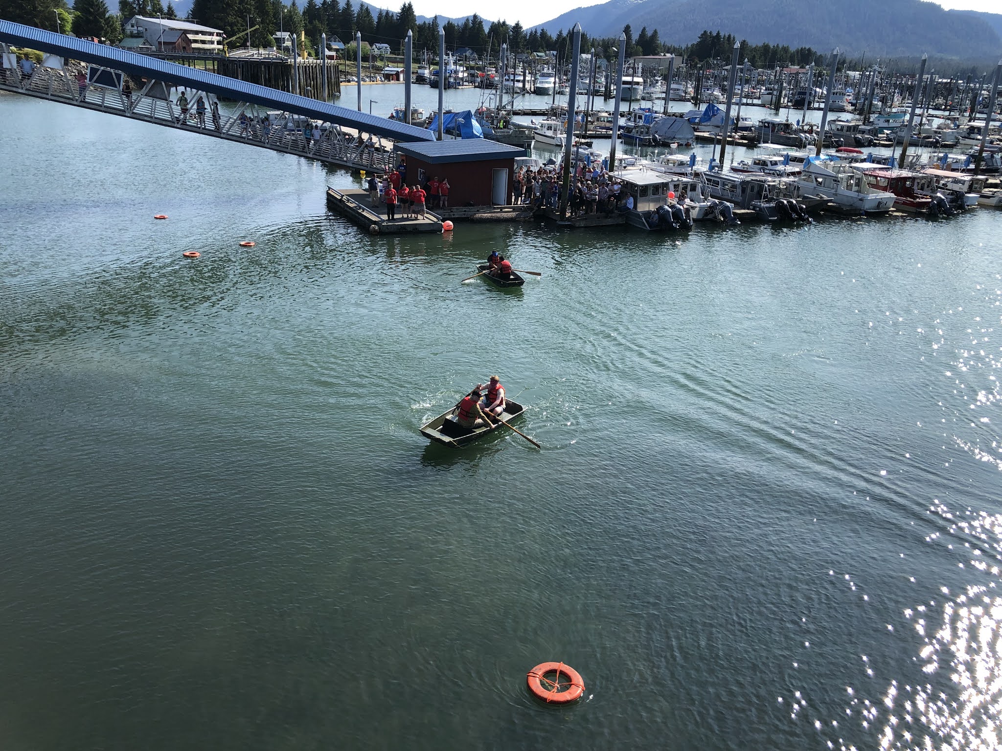
Late afternoon we watched the blind-fold row boat races, the herring toss and the log rolling contest in Middle Harbor.  It was a fun weekend and we enjoyed all of the activities.

The blind-fold row boat races in Middle Harbor. 
The person rowing was blind-folded and the person at the front of the boat was giving instructions. 
The goal was to row from the dock (at the top of the photo), around the buoy (at the bottom of the photo) and back to the dock - more difficult than it sounds.

The kids herring toss.  
Like a bean bag toss but with herring (bait fish).  
If the fish went through the center of the ring it was worth 3 points;
 if it hit the edge of the ring it was worth 1 point.

The end of one round of log rolling.  
This was a semi-final with last year's women's champion and 
the woman who eventually won this year's women's competition.

Back to work on Monday, well at least for some of us.  Steve and I decided to hike the Raven's Roost trail on Mitkof Island while Dave worked on the alternator project.  The Raven's Roost trailhead starts at the east end of the Petersburg airport runway, about 2 miles from the harbor, and then climbs ~1800 feet over 3.5 miles.  The trail has recently been upgraded and they are in the process of building a new cabin at the top.  Although the overall distance was further than the Petersburg Mountain trail (we logged 11 miles today), it wasn't as steep and didn't take us as long to hike.  It was a beautiful day for a hike and the view of Petersburg and the north entrance to the Wrangell Narrows was spectacular.

Steve climbing a set of stairs on the Raven's Roost trail.

The view of Petersburg and the north entrance to Wrangell Narrows.

By Tuesday Dave had finished installing the new fuse, fuse holder and positive cables along with our spare alternator and we were ready to do some testing.  We spent most of the day testing the spare alternator, the regulators, the aftermarket Balmar alternator and the wiring harnesses.  We finally concluded that both regulators were good and the aftermarket Balmar alternator was good but we were still getting voltage readings on the spare Perkins alternator when we should have been seeing zero.  After talking to the Balmar technical support group, we tried some different tests but still weren't getting the results we expected.  Very frustrating.

Later that evening, while I was on a Zoom call with some friends, Dave went back down to the engine room to check for loose wires and found that the negative battery cable was disconnected.  He had removed it while installing the new fuse and positive cable and had forgotten to reconnected it.  We repeated some of our earlier tests and everything looked good.

Wednesday morning, Dave reinstalled the original alternator, the one we assumed had burned up, so we could test it.  We found out that it was good and concluded that the positive cable and fuse/fuse holder were the only things damaged which was good news.  The new alternator, regulator, wiring harness and circuit protection unit arrived early Wednesday afternoon.  After studying the new equipment, we decided it was going to be a bigger project than anticipated to install and realign everything and since we are operational with the exisiting equipment and new wiring, we'll save that project for another day.

This morning a mechanic come aboard to look at changing the alignment for the alternators that we have in place.  After discussing the set-up, he gave us some ideas to eliminate the interference between the two alternator mounts that is causing a lot of belt dust so we added that to our future alternator project list.  Bottom line is that after we get the main engine reassembled and the engine room cleaned up later today, we will be ready to start cruising again.

We made a list of the things we want to finish up while we are in town and plan to leave early tomorrow afternoon to catch the currents going south down Wrangell Narrows.

Until next time...

Back to the USA - Houston, TX and Charleston, SC

Location: Houston, Texas, USA We ended our excellent 325 day adventure in Europe by flying from Amsterdam to Houston, Texas.  We had a wonde...