The US / Canada border was still closed to non-essential travel when we were ready to go north to Alaska. We had visited many places in Puget Sound; some we had never been to before and others that were favorites from past visits. We had used up all of our time in Washington and it was time to head north. Although US-flagged pleasure boats are still not allowed to travel as tourists within Canadian waters, CBSA (Canada Border Services Agency) has established guidelines that allow transit through British Columbia (BC) from Washington to Alaska and back.
Prior to departure, we checked MarineTraffic.com on a
regular basis and watched a steady stream of US-flagged vessels making their
way north up the BC coast to Alaska. We listened
to a webinar that explained most of the rules and what to expect when clearing
customs and during transit. Some of the
rules are: you had to have a transit
plan showing your stops along the way; you were not allowed to stop at any First
Nations Communities; you were only allowed to stop at shore side facilities if
you needed fuel, water or groceries but these stops were to be kept to a
minimum; no fishing or tourist activities were allowed. Of course, in an emergency you could get
assistance. We carry plenty of fuel and
water and we stocked up on groceries in Anacortes a few days prior to our
departure so all of our stops in BC were anchorages.
Originally, because we were unsure of how long it would take
to clear customs, we had planned a short voyage for the day. Since it didn’t take as long as expected, we decided we could transit Dodd Narrows and anchor somewhere near
Nanaimo for the night. Dodd Narrows is a narrow, deep passage south of Nanaimo where the currents can run up to 9 knots. Although the narrows is short, it is best taken at slack water. The tide and
current tables told us that slack water at Dodd Narrows was at 16:38 and we
decided we could safely transit through at ~16:00 with ~2 knots of current flowing
with us. We arrived south of the narrows
about 15:00, too early to go through, so we anchored up behind an island nearby
to wait. We heaved anchor at 15:45 and made
it through the narrows with no issues.
In Northumberland Channel, just north of the narrows, we saw three orcas
heading south. We motored up to Hammond
Bay, north of Nanaimo, and anchored up for the night.
We heaved anchor at 8:30 and headed north. “Whiskey Golf”, a restricted area north of
Nanaimo that the US and Canadian Navies use to test torpedoes and ships’
systems, was active today so we skirted around the west side. The current was mostly with us and we cruised
along at 7.5 – 7.8 knots most of the day.
Once we got to the current shear line, where the ebb and flood currents
meet, north of Shelter Point, our speed went all the way down to less than 4
knots, then back up to 5 and finally back up to 7 knots.
The timing looked good for us to arrive at Seymour Narrows just after 19:00 with ~2 knots of current in our favor; we continued north and made it through with no issues. We decided to ride the current for another hour and anchored up in Otter Cove, south of Chatham Point at 20:30. A long day but worth it to get the narrows behind us.
Wednesday, May 12, 2021 – Otter Bay, BC to Spout Cove,
Hanson Island, BC (55 nm, 7.5 hours): We left Otter Bay at 5:45 to catch the ebb
current flowing west through Johnstone Strait.
 |
| Chatham Point Lighthouse, just around the corner from our anchorage in Otter Cove |
This is another area with strong currents, and if the wind
is blowing from the west up the strait while the ebb is flowing out to the
west, the seas become short and steep.
The wind was light today, with a low ceiling and some fog.
We had to dodge a few logs along the way but
overall a pleasant voyage.
 |
| A tug towing a loaded log barge heading east and an LST heading west in the fog in Johnstone Strait |
We turned north out of Johnstone Strait into Blackney
Passage and anchored up in Spout Cove on the north side of Hanson Island at 13:30,
about the time the current changed from ebb to flood.
We unlaxed, did a few minor boat chores and
checked the weather for tomorrow’s voyage.
If the weather cooperated, we planned to go around Cape Caution but we
plotted an alternative route to an anchorage south of the Cape just in case.
 |
The shoreline at Spout Cove.
Our solar panels are in the foreground soaking up the sun and keeping the batteries charged up. |
Thursday, May 13, 2021 – Spout Bay, BC to Pruth Bay,
Calvert Island, BC (90 nm, 12.3 hours):
We heaved anchor at 5:40 and motored out of Spout Bay. It was overcast with a low ceiling and light
rain. The current was with us for most
of the morning and we averaged 8+ knots.
The weather was acceptable for going around Cape Caution and we rounded the
cape ~13:30. For entertainment (and information) we have been listening to
Traffic on the VHF radio but there weren’t many boats out today and the radio
was fairly quiet. We turned west around
the north east corner of Calvert Island into Kwakshua Channel ~18:00 and were
anchored up in Pruth Bay by 18:30.
Pruth Bay is the home of the Hakai Beach Institute with
access to good hiking trails and sandy beaches.
In normal times, this is a very popular anchorage but with COVID
restrictions in place, the institute and the island are closed to guests. We were surprised to find that we were the
only boat in the anchorage. The
institute also provides limited Wi-Fi access and we were able to anchor close
enough to pick up a signal and check our e-mails.
 |
| Sunrise at Pruth Bay |
We took a day off on Friday to wait for the winds and the
seas offshore to settle so that we could take the offshore route up the north
coast of BC.
Saturday, May 15, 2021 – Pruth Bay, BC to Tate Cove,
Aristazabal Island, BC (84 nm, 11 hours):
We fired up the main engine at 7:00 this morning and headed north up Meay
Inlet to Hakai Passage then turned west/northwest into Queen Charlotte Sound. The road less traveled, Queen Charlotte Sound
is the outside route through northern BC.
Most boats take the inside route up Fitz Hugh Sound, through Loma
Passage to Seaforth Channel, up Finlayson and Tolmie Channels and into
Grenville Channel. The inside route is better
protected with numerous anchorages to duck into if the weather changes and
several marinas providing fuel, water and groceries. Last fall we had travelled south down the
inside route from Alaska to Washington.
Since the weather was good, we decided to take the outside route so that
we could see some different stretches of coastline.
The skies were gray as we motored across the south end of
the Goose Islands, along the southwest coast of Price Island and up the west
coast of Aristazabal Island. We turned
east and motored through the Wall Islets, along the north shore of Thompson
Island and then south into Tate Cove where we anchored for the night.
 |
| Tree at the entrance to Tate Cove |
Sunday, May 16, 2021 – Tate Cove, BC to Patterson Inlet,
Pitt Island, BC (50 nm, 6.6 hours): It
was foggy and rainy this morning when we left Tate Cove to continue our
journey north.
We cruised up Estevan
Sound between Campania Island and the Estevan Group of islands, across Nepean
Sound and into the southern end of Principe Channel, between Banks Island and
Pitt Island.
We turned east into
Patterson Inlet, on the west side of Pitt Island and were anchored up by
15:30.
 |
| Trees from a landslide on the shore near the entrance to Patterson Inlet |
 |
| The mountains surrounding the head of Patterson Inlet |
Monday, May 17, 2021 – Patterson Inlet, BC to Hunt Inlet,
Porcher Island, BC (59 nm, 8 hours):
Departure time this morning was at 10:00 to catch the flood flowing
north so we did a few boat chores before leaving the anchorage.
We cruised up Principe Passage then turned
into Petrel Channel and wound our way north up the east side of McCauley
Island.
Our destination for tonight was
Hunt Inlet on the north side of Porcher Island.
Both sides of Hunt Inlet are lined with interesting houses, buildings
and docks.
We anchored up at the head of
the inlet at 17:30 and settled in for the night.
 |
| Sunset at Hunt Inlet |
 |
| A building and boat / seaplane dock in Hunt Inlet |
Tuesday, May 18, 2021 – Hunt Inlet, BC to Brundige Inlet,
Dundas Island, BC (41 nm, 6 hours): Anchor
up at 6:45 this morning for a short journey to Brundige Inlet on the north side
of Dundas Island.
It was overcast, 46F/9C,
winds were from the west 15 – 20 knots and the seas were choppy.
There were a few other pleasure boats headed north but
most were faster than us.
Once we got
into the lee of Dundas Island it was smooth cruising.
We cruised by the Green Island lighthouse,
turned west around the northeast tip of Dundas Island and then south into
Brundige Inlet.
 |
| Green Island Lighthouse, east of Dundas Island |
We anchored up south of Fitch Island, ate our lunch and
settled in for the afternoon.
We watched
a small sailboat come into the cove mid-afternoon.
Our last anchorage in BC, this was the first
that we’ve shared with another boat.
Tomorrow
we cross the border into Alaska.
Wednesday, May 19, 2021 – Brundige Inlet, BC to
Ketchikan, Alaska (55 nm, 8 hours): This
morning we got up at 5:15, made coffee and ate our breakfast then heaved anchor
and motored out of the inlet at 5:45.
The sailboat was heaving their anchor at the same time and they followed
us out. The early departure was so that
we would be across Dixon Entrance before the tide changed from flood to ebb. We took down our Canada flag after we crossed
the border and cleared into the US using the CBP Roam app once we picked up a
cell phone signal from Ketchikan. Space
was available at the Casey Moran Harbor, aka City Float, right in the heart of
downtown and we tied up to the docks there about 13:00. The guys on the dock gave us some restaurant
recommendations so we walked up to Annabelle’s and had chowder and seafood for
lunch.
 |
| Welcome to Ketchikan |
We spent the afternoon doing town chores, i.e. getting our
fishing licenses and visiting the local book store.
A walk along Creek Street, which used to be Ketchikan's red light district and Married Man’s
Trail, the "back door" to the red light district, which follows Ketchikan Creek upstream to the fish ladder, finished the afternoon.
As per one of our guide books, the local joke is that at Ketchikan Creek, both salmon and men went up the creek to spawn. For supper
we went to Bar Harbor and had a nice meal.
We spent Thursday and Friday in Ketchikan doing more town chores
– grocery shopping, trips to the hardware store and fishing store, laundry,
etc. The bus was free so we took
advantage of that and did some touring around the south and north ends of
town.
Saturday, May 22, 2021 – Ketchikan to West Arm, Kendrick Bay (38
nm, 5.3 hours): Although we enjoyed
our time in town and the opportunity to stretch our legs, three days were more
than enough and we were anxious to get out into the wilderness. We decided to cross over to Prince of Wales
Island to explore the bays, inlets and towns along the east and west coasts. Before leaving the docks, we topped up our
fresh water tank and set up the crab and shrimp pots. We pulled out of the harbor at 10:30 and
headed down Nichols Passage and across Clarence Strait. Our first stop was Kendrick Bay. We dropped off the shrimp trap and the crab
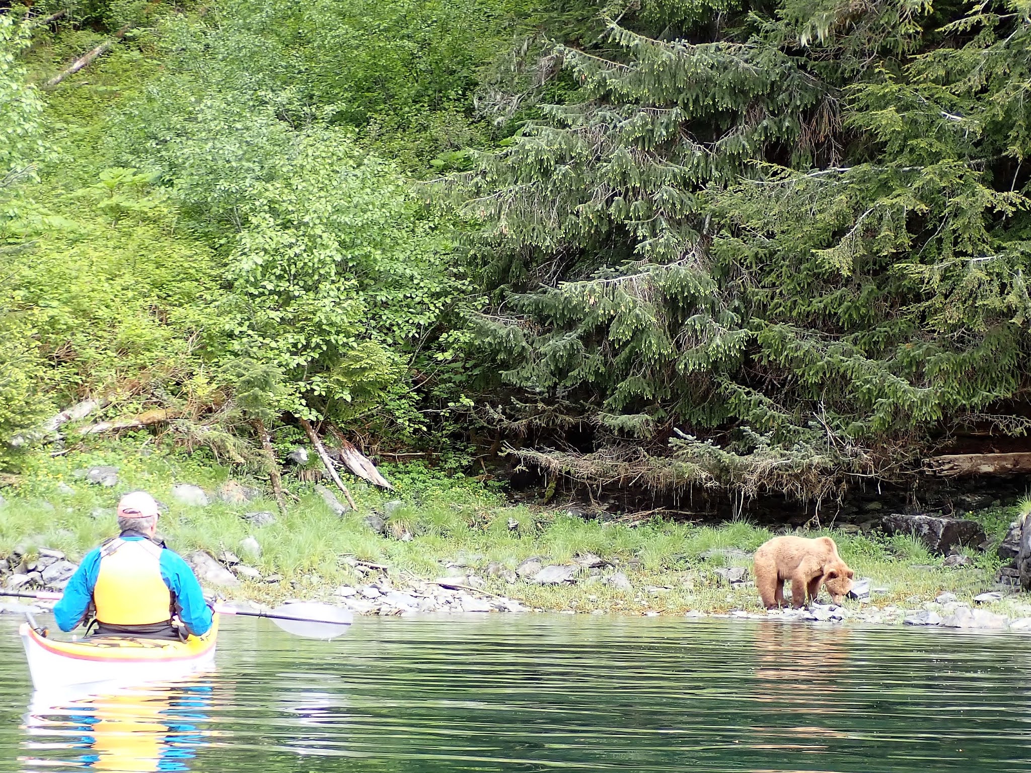
trap then made our way to the head of the west arm where we anchored up. We spotted a black bear along the shoreline
about ten minutes after setting the hook.
 |
| The shoreline and mountains at the head of West Arm in Kendrick Bay |
Sunday morning, after coffee and breakfast and checking into
the Boater’s Net with Darlene, we finished our high-level cruising plan for the
summer.
Our plan is to do a clockwise loop through the islands, visiting places we haven’t been to
before and revisiting some of our favorites.
We hope to spend at least two nights at each location, which gives us a
travel day and an exploring day.
There
are a few spots where we’ll only spend one day and some where we’ll spend
several days.
We spotted two black bears, one black colored and one with a
rusty brown coat, working their way along the shoreline. It was raining so we spent most of the day
doing boat chores. Late in the
afternoon, the rusty colored bear ambled along the shoreline, scratching his
back on the trees as he went; we enjoyed his show.
 |
| Leaving Kendrick Bay |
Monday, May 24, 2021 – Kendrick Bay to Kassa Inlet (50
nm, 6.5 hours): We left the
anchorage this morning at 6:00.
There
were no crabs in the crab trap and only two shrimp in the shrimp trap so that
was disappointing.
Just north of Cape
Chacon we spotted whales, eagles and dolphins feeding along the shoreline.
We cruised around Cape Chacon at the southern
tip of Prince of Wales Island and turned north into Cordova Bay on the west
side.
We stopped to fish at a high spot
in Eureka Channel.
Dave put his line
down to the bottom and had a fish almost immediately.
I waited for him to reel his line in, then
put mine out and caught a fish.
They
were both good size black rockfish (black bass).
Two was plenty for us so we put up our rods
and continued north.
Two nice fish in
less than ten minutes – catching is definitely a lot more fun than fishing.
 |
| Dave putting his line in the water, Eureka Channel on the west side of Prince of Wales Island |
 |
| B with a black rock fish (black bass) on the line, Eureka Channel |
We dropped off the shrimp trap at the entrance to Kassa
Inlet and the crab trap on the north side of Kassa Island then anchored up in the small cove on the west
side of Kassa Island.
Late evening a small
black bear came out of the woods and worked its way along the shore.
 |
| Black bear on the shore, Kassa Inlet |
We were planning to kayak around the inlet Tuesday but it
was raining out so we stayed aboard and did some chores.
We spotted a different bear, this one was
black with a rusty stripe across his hindquarters, on the shore
mid-morning.
Early evening the small
black bear and the rusty striped bear were both out eating grass and turning
over rocks.
 |
| Two black bears on the shore, Kassa Inlet |
Wednesday, May 26, 2021 – Kassa Inlet to Hydaburg (26 nm,
3.6 hours): We had our breakfast and
coffee this morning, checked into the Boater’s Net with Darlene, put a pork roast
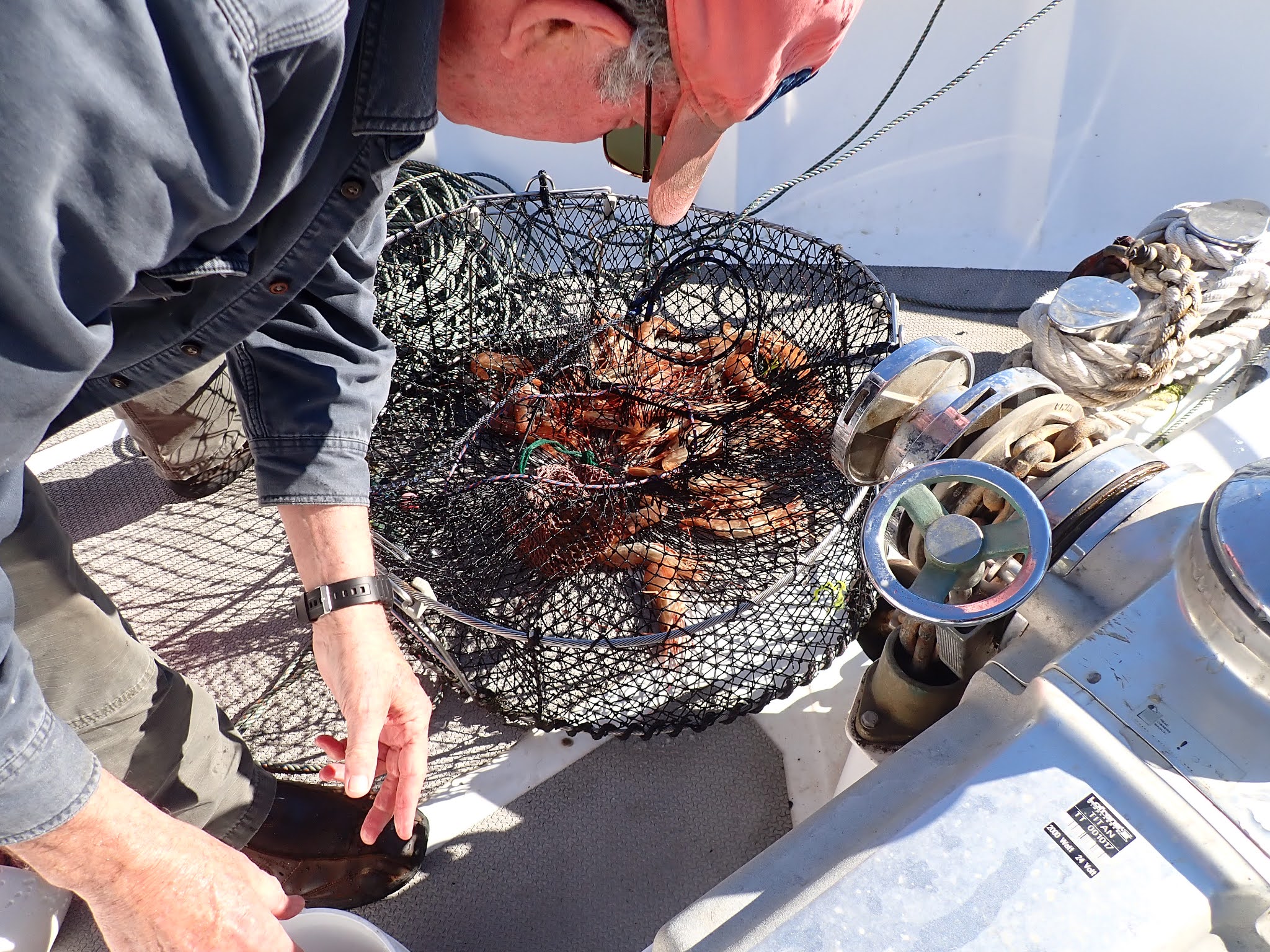
in the crock pot, checked for bears then heaved anchor at 10:00.
The crab pot was empty but we caught 26 large
spotted prawns in the shrimp trap, the best haul we’ve had in a long time.
 |
| Dave pulling the crab trap, no luck today. |
 |
| The shrimp trap with 26 large spot prawns in it |
We pulled into the Hydaburg harbor ~14:15 and tied up on the
inside of the breakwater dock.
We
settled in then walked up the dock to check in with the harbormaster.
Hydaburg is one of the largest Haida communities in North America.
There was a group of kids swimming near the shore – too cold
for us, but they were having a good time.
We walked into town to check out the totem park, then to the grocery store and
the café.
 |
| Totem pole in the Hydaburg Totem Park |
 |
| Totem Pole in the Hydaburg Totem Park |
 |
| Mural on the back of the Hydaburg Library |
Everyone we met was super friendly.
While we were at the totem park, a lady came
out to make sure we didn’t miss the mural painted behind the building.
At the grocery, we asked if they had ice.
The owner said no but she thought her mother
might have some extra so she called to ask.
Her mother only had one extra bag so we said not to worry, we would pick
some up when we got to Craig.
The café
was closed, but the owner came out and talked to us to tell us what was on the
menu for tomorrow.
As we made our way
back to the boat, we stopped and traded stories with a group of fishermen on
the dock.
 |
| Fishing boats in the Hydaburg Harbor |
 |
| Sunset at Hydaburg |
Thursday was a beautiful bright sunny day, the best we’ve
had since arriving in Alaska.
We spent
the morning doing some outside boat chores, like scrubbing green algae from around
the hatch covers and the decks.
At 11:30 we walked up
the hill to the main road that connects Hydaburg to Craig, then down to the
beach road and along the shore to the café.
 |
| B at the Welcome to Hydaburg sign |
 |
| Mileage sign on the main road between Hydaburg and the other communities on Prince of Wales Island |
 |
| Two fishing boats on the rocks in a cove south of downtown |
The café wasn’t open so we finished the loop through town,
stopping to talk with a lady about the Haida culture and the town. She told us we should come back at the end of
July which is when they have their culture festival. We made fish tacos with the rest of our black
bass then did more outside chores and enjoyed the sunshine.
Friday, May 28, 2021 –
Hydaburg to Craig (33 nm, 4.7 hours):
While lying in bed early this morning, I thought I heard someone on the
dock crying “Help, Help, Help” so I jumped up to see what was happening. There were a few fishermen getting ready to
go out for the day, but I couldn’t see anything urgent going on. I opened the door and discovered that the
“help” calls were some ravens (the tricksters) along the shore. I was wide awake, so drank some early morning
coffee while watching the activities in the harbor. The king salmon are running and the halibut
are biting so most of the boats were either getting ready to troll for salmon or rigging up
their halibut gear.
We left the dock at 10:30
to catch slack water in the Tvelak Narrows.
It was close of low tide when we left and we could see all of the rocks
and shoals in the area. We tied up to
the tee head in Craig’s north harbor ~15:00.
After settling in, we walked up to the harbormaster’s office (closed for
the weekend), then through town past the totem park, to the hardware store
(closed) and to the grocery store (open).
We bought a few things, then headed back to the boat. For supper, we went up to the pizza parlor.
 |
| The Healing Heart Totem Pole in Craig |
 |
| The Story about the Healing Heart Totem Pole |
Saturday morning, we
walked up to the café for breakfast then walked along the shore west of the South and North Harbors and back to the boat to do boat chores.
We’ve been having some issues with noise, i.e. RFI (radio frequency interference), on the depth sounder and every
now and then our environmental screen goes off for no reason so we spent the
morning troubleshooting the electrical wiring under the pilot house
console.
 |
| Dave troubleshooting the wiring under the pilot house console. |
 |
| The spaghetti bowl of wires under the console |
We cleaned ring terminals on the fuse block and moved some wires around including the “optional” ground shield wire from the battery monitor.
It was on the same ground terminal as the depth sounder.
We moved it to the FM radio ground terminal and then the radio didn’t work.
After some internet research, we decided to go with the “optional” option and left it disconnected.
The FM radio worked and the environmental monitor came back on but we’ll have to wait and see if the noise in the depth sounder disappears.
(Note: as of the writing of this blog, we still haven't found the source of the noise. Suggestions are welcome.) |
| B putting wires back on to the fuse block terminals. |
After lunch, we went out
for walk around the shore east of the harbors, picked up a few things at the
hardware store and the grocery store, then spent the evening on the boat.
Sunday, May 30, 2021 – Craig to Klawock (6 nm, 1 hour): The wind had picked up before we went to bed
last night and it was raining and overcast this morning. We topped up our water tank and took up the
trash then fired the main engine and pulled away from the dock at 9:30.
 |
A bald eagle sitting on top of the Craig North Harbor breakwater.
The breakwater is made up of two barges with containers and boat / fishing gear on top.
|
Today we had a very short run north to the small town of Klawock, a Tlingit community on the west coast of Prince of Wales Island.
Outside the Klawock harbor, a
cargo ship was loading timber and we slowed down to watch.
 |
| Ship loading timber near Klawock |
 |
| Close up of the timber loading operation. |
 |
| Close up of the timber loading operation. The guys on the left are securing a bundle of logs for the crane to pick up and load on board the ship. The guy near the middle is operating a small skiff that helps to push the logs into the bundles. |
We tied up at the town dock about 10:30 and spent the rest of the morning on the boat waiting for the rain to move
through.
The rain quit early afternoon
so we walked up the hill to the totem park, then walked a loop around this part
of town.
It rained again late afternoon
and we spent the time on the boat doing internet stuff.
 |
| The Klawock community canoe |
 |
| Old boilers from the cannery |
 |
| A bald eagle south of the Klawock harbor |
 |
| The Klawock Totem Park |
Monday, May 31, 2021– Klawock to Kaguk Cove (27 nm, 3.8
hours): We pulled away from the dock
this morning at 7:00 with a light rain falling.
 |
Seabiscuit at the Klawock Dock
|
As we motored north, we spotted some whales spouting near
Catalina Island.
The wind was blowing 20
– 25 knots with gusts up to 30 and we had some SW swell on the stern.
There are some protected passages behind the
islands on our route today and we took advantage of them.
The first passage was along the east side of St.
Philip Island, where we got out of the wind and swell.
Sea otters were scattered amongst the kelp
near the rocks at the south entrance.
North of St. Philip Island is the Harmony Islands Passage with Salt Lake
Bay at the southern end and the Tonowek Narrows at the northern end.
After transiting through the Tonowek Narrows,
we turned east and then south into Kaguk Cove where we anchored up for the
night, well protected from the winds and seas.
Tuesday, June 1, 2021 – Kaguk Cove to Kell Bay, Affleck
Canal, Kuiu Island (44 nm, 6.1 hours):
Light rain was falling this morning when we left Kaguk Cove at 8:30. We spotted a bear on our way out. Nothing in the crab trap; the water in the
area wasn’t deep enough for shrimp so we didn’t bother putting the shrimp trap
out yesterday afternoon.
 |
| B pulling up the crab trap in Kaguk Cove |
 |
| B giving the sign that the crab trap is empty again |
We cruised north through Karheen Passage, then turned west
into Sea Otter Passage and north again to cruise along the east coast of Warren
Island.
There were a few fishermen
working along the northeast coast of Warren Island, along with the sea birds
and some whales.
We crossed Sumner
Strait and entered Affleck Canal which splits the southern portion of Kuiu
Island.
About 1/3 of the way up Affleck
Canal, we turned west into Kell Bay and dropped off the shrimp trap and the
crab trap.
We could hear sea lions
roaring on the rocks as we dropped off the crab trap and we wondered if we were
wasting our time putting it out.
We
worked our way around the islands on the south side of the bay and anchored in
Kell Bay Arm.
Wednesday, June 2, 2021 – Kell Bay to Shelter Cove,
Tebenkof Bay, Kuiu Island (51 nm, 7.1 hours): We had been checking the weather and there was
a big low off the coast heading this way.
We wanted to get around the south end of Kuiu Island and up Chatham
Strait before the south winds started blowing so we moved again today. Before heaving anchor, we watched two bald
eagles scouting for fish at the head of the bay. As we made our way around the islands out of
the cove, we spotted a bear on the shore.
 |
| Looking out the pilot house window at the Kell Bay shore |
 |
| A black bear on the shore as we leave Kell Bay |
The crab trap was empty as expected and so was the shrimp trap.
It was raining and foggy so we switched on the radar as we cruised south down Affleck Canal.
The fog lifted as we rounded the corner at Cape Decision and we had a good view of the lighthouse.
 |
| The Cape Decision Lighthouse |
We cruised north up Chatham Strait along the west coast of Kuiu Island. Just south of our turn into Explorer Basin, a small group of Dall’s porpoises
joined us for a ride on our bow wake but they didn’t hang around for long.
 |
| Splash of a Dall's porpoise playing in our bow wake |
It looked like the fog was going to settle over us again as
we made our turn east into Explorer Basin, but it was just a thin sliver and the visibility
in Tebenkof Bay was good.
We dropped off
the shrimp trap south of Gap Point, tried to catch a fish (no luck) then wove our
way through the islands north of Elena Point and into Shelter Cove.
Tebenkof Bay, on the west side of Kuiu
Island, is surrounded by the Tebenkof Bay Wilderness Area; Shelter Cove is in
the northeast arm of the bay, has a large flat bottom for easy anchoring, has a
creek at the head of the cove and is surrounded by grassy flats for good
wildlife viewing.
We spotted a lot of
sea otters and a seal on our way in.
We anchored near the head of the north cove and settled in
to wait out the rain. Late in the afternoon, we spotted two black bears and two deer along the shore in the grass on the east side of the cove
and watched a crane fly by.
Thursday it rained all day and we did inside chores, unlaxed
and read our books. Along with the sea
otters eating clams and playing in the cove, we watched a doe pick her way
along the east shore and a bear in the grass at the head of the cove.
 |
| Dave reading in the pilot house on a rainy afternoon |
It was still raining when we got up on Friday and the
barometer had dropped down to 999 so we were hoping the low had moved east of us
and the rain would quit on Saturday. We
spent the day doing more indoor chores, reading and checking the shoreline for
wildlife. We spotted a bear at the head
of the cove mid-afternoon and, early evening, we saw two bears eating grass on
the west shore. One sea otter hung
around close to the boat most of the afternoon and entertained us with his
swimming, diving and clam eating.
 |
| Our engine room bilge cleaning project, a good rainy day chore. The bays on the right side of the photo have been cleaned, osphoed, primed and painted. The bays in the middle are a work in progress. |
It was still raining when we woke up Saturday morning, but
the skies were lighter and the barometer was rising. After checking in with Darlene on the
Boater’s Net, we did a few chores and watched the wildlife in the cove: two bears near the creek at the head of the cove
and 6 sea otters swimming past the boat into the small cove south of here. We saw two hunters cruise by in their dinghy toward the south cove early afternoon. They
stopped to talk on their way back out and told us that they were from
Colorado, a float plane had dropped them off and they were camping in Elena
Cove just north of us. It rained off and
on most of the day and we did more unlaxing and inside chores.
 |
| Afternoon sun in Shelter Cove |
 |
| Sea otter swimming near the boat. |
Sunday, June 6, 2021 – Shelter Cove to Red Bluff Bay, Baranof
Island (37 nm, 5.1 hours): Today was
a bonanza of wildlife viewing.
The sea
otters were out in the cove this morning when we heaved anchor at 6:30.
Both the crab and shrimp trap were empty but
the crab trap buoy was full of sharp teeth marks – we figured the sea otters
must have been curious.
Out in Chatham
Strait, just past the entrance to Tebenkof Bay, we saw a large pod of
humpback whales (20+), two orcas, a small pod of Dall’s porpoises and three bald eagles,
all feeding on the shoals of fish that we could see on the surface of the
water.


