Thursday, May 14, 2015

Mexico in the Rear-view Mirror

Location:  Chula Vista Marina, Chula Vista, California

The last blog ended in the Sea of Cortez, near the town of Loreto.  Since then we have made our way around the southern tip of the Baja Peninsula, northwest along the outside of the peninsula and across the border into the United States.  We spent over a year in Mexico.  We had the opportunity to see and do a lot of things, to experience Mexican culture, people and food and to enjoy the natural wonders and wildlife that the various regions have to offer.

To make this blog easier to read (and type), we’ll break it up into three parts:  Puerto Escondido (where the last blog ended) to La Paz; La Paz to San Jose del Cabo (with friend Bob aboard); and, San Jose del Cabo to Chula Vista (the Baja Bash).

Puerto Escondido to La Paz
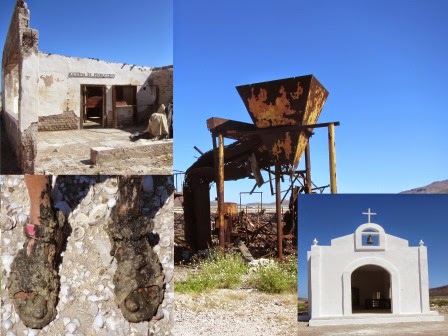
From Puerto Escondido, we cruised to Bahia Salinas, on the east side of Isla Carmen.  There is an abandoned salt mining operation and pond here so we went ashore to explore.  The machinery from the operation is slowly being dismantled and the school and church are abandoned.  They no longer flood the salt ponds, but there is still a large area flooded with water and you can see the salt crystals that have formed along the shoreline.  There are some new buildings – lodging for hunters that come in to hunt big horn sheep that have been introduced to the island.

Bahia Salinas - Top Left:  Abandoned salt mine administration office; 
Bottom Left:  B's feet after sinking into the mud crossing a salt pond; 
Bottom Right: Church; Top Right: Abandoned salt mining equipment
Looking across the salt pond at Bahia Salinas

Next stop Aqua Verde, a small fishing village on the east coast of the Baja Peninsula.  After we anchored up, we dove into the water for a swim and did some snorkeling between the boat and the shoreline.  The next morning we launched the dink and went out to snorkel around Roca Solitaire.  The water was super clear and we could see lots of fish.  We used our new underwater camera for the first time and the pictures turned out good.  We had fish tacos at a small beach restaurant operated by the Aqua Verde Women’s Co-op.  We knew the fish was fresh because one of the ladies bought a yellow tail right off of the fishing panga as it came in from offshore.

Roca Solitaire near Aqua Verde

As we continued to move south, our next stop was Los Gatos – a beautiful anchorage with red rock formations along the coast.  We were the only boat in the anchorage and after we got set-up, two guys in a panga stopped by to see if we wanted any fresh fish, lobster or clams.  We asked them for some of each.  They had the fresh fish aboard so they filleted the fish there and then told us they would be back later that afternoon with the lobsters and the clams as they had to go and gather them.

Coyote prowling the beach at Los Gatos

B enjoying steamed clams - Los Gatos 
Sunset - Los Gatos
Dave enjoying steamed clams - Los Gatos

We went ashore and walked the beach while we waited for them to return.  Later that afternoon a group of kayakers came into the cove just north of where we were anchored and set-up camp.  Tour groups operate trips where people spend a week kayaking, starting in Loreto and going south toward La Paz or vice versa.  They kayak along the shore and out to the islands, whale watch, snorkel and visit the towns along the coast and camp in a different location each night.

Kayaker camp - Los Gatos

Red rock formation - Los Gatos
B hiking in the red rocks - Los Gatos
Red rock formation - Los Gatos

Dave hiking in the red rocks - Los Gatos


Pelican on the bow - Los Gatos. He must have hurt himself landing.  
He tried to make it to the bow rail but didn't have enough energy 
so he stayed there as we heaved the anchor.

Pelican - finally rested enough to make it up on the rail.  
He rode on the bow for about 30 minutes before flying to shore.

Next we moved to San Evaristo, another small fishing village.  There are several smaller villages just north of San Evaristo that have no road access so all their supplies are brought here by car and then loaded into pangas to be transported to the other villages.  There is an active salt mining/salt pond operation just north of the village.  One of the locals recently opened a small beachside restaurant in the south part of the cove so we dinghied ashore for supper.  The menu consisted of fresh fish prepared one of five ways; I had the ceviche and Dave had the fish stew.  Both were delicious so we went back the next night and I had the fried fish and Dave had the grilled fish; again, both were delicious.

From San Evaristo, we cruised to Isla Partida and anchored at Ensenada Grande.  Isla Partida and Espiritu Santo are two islands close to La Paz.  Both islands have a number of protected anchorages on their west sides.  The water is clear and warm so we did some snorkeling.  The next day, Saturday, we cruised into La Paz and got a slip at Marina de La Paz.  We spent a few days doing boat chores (cleaning, filling propane tanks, laundry, maintenance) and projects (dinghy leak repair), provisioning and finding our way around while waiting for Bob to join us.

La Paz to San Jose del Cabo (with Bob)
Bob arrived in La Paz on Tuesday evening, April 7th and met up with us at the marina cafĂ©.  The next day we bought fresh fruit and veggies, Bob went for a run along the malecon and we had supper at a local barbeque joint.  Thursday morning we pulled out of the marina early in the morning in order to catch the slack tide and motored up to Caleta Partida, an anchorage between Isla Partida and Espiritu Santo.  We launched the dink and went snorkeling near a reef at the northern point of the cove entrance and then went to the next cove over, El Cardoncito, and Bob did some snorkeling along the shore line.  The water was very clear and we saw plenty of fish and starfish and also some rays.

Dave catches a bonito.

Friday morning we heaved anchor and moved about 6 miles north to anchor near Isla Islotes.  These islands are known for the many sea lions that live here.  Many tour boats from La Paz come out here for day trips and the sea lions are used to having people in the water with them.  We took the dink close to the rocky shore and hopped over the side to do some snorkeling.  Most of the sea lions were still on the rocks but one got into the water and swam close to Dave and me.  Bob went closer to shore and was surprised when a sea lion swam up and rubbed against him.  It was fascinating to be in the water with them so close and to see what graceful swimmers they are.

Sea lions on the rocks at Isla Islotes.

Snorkeling - Los Islotes.
Up close and personal with a sea lion.


School of small fish - Los Islotes.

Sea lion - Los Islotes.

Sea lions on the rocks - Los Islotes

We swam with the sea lions for about an hour, until the tour boats started to arrive, and then moved north another 12 miles and anchored near Isla San Francisco for lunch and a hike up the hills and along the beach.  About 3:30 p.m. we pulled anchor again and moved north to San Evaristo for the night.  We wanted to Bob to experience the fresh fish at the beachside restaurant there.   Saturday morning, we headed south and did some fishing over three sea mounts northeast of Isla Islotes.  We didn’t catch any big fish, but Bob caught and released two bonito.  From there we went to Playa Bonanza, an anchorage on the east side of Espiritu Santo and did some snorkeling.  Bob cooked us a gourmet supper of salmon patties, made with canned salmon that he and his family had caught fresh in Alaska last season, and bacon-wrapped asparagus.

Graceful swimmers.

Bob swimming with a sea lion.

A herd of sea lions.

Sunday we headed south to Ensenada de los Muertos.  This is an area where boats stop on their way north from Cabo San Lucas into the Sea of Cortez, as a staging area to cross the Sea of Cortez to/from Mazatlan, and as a stop going south from the Sea of Cortez to Cabo.  Ensenada de los Muertos, the traditional name for this area, means “cove of the dead”.  As a marketing strategy, they are trying to rename it Los Suenos (The Dreams) but so far it isn’t sticking and most cruisers call it Muertos.  There is a small resort here so we went in for supper.  Monday we cruised from Muertos to Los Frailes, another stop on the way south to Cabo.  We fished along the way but didn’t catch anything worth keeping.  Once we anchored up, Dave and Bob swam and did some bottom cleaning.
Tropical fish.

Tropical fish.

Tuesday we made the last run down the inside of the Baja Peninsula into San Jose del Cabo.  There are some fishing banks along the way, so we put out the fishing lines and cruised over the areas where the fishing is supposed to be good.  This is the first day since we left La Paz where Bob didn’t at least catch a bonito.  We pulled into the marina just after lunch and walked the docks and explored the area.  There are lots of sport fishing boats and large yachts in the marina.  We decided to walk into town for supper and had a nice dinner at a restaurant overlooking the square.  Wednesday morning we launched the dinghy and took it over to the fuel dock to get some gasoline and then explored the little town of La Playita.  Bob caught a taxi to the airport at noon and Dave and I dinghied over to the Marinero Borracho (Drunken Sailor) restaurant for lunch.

B and Doofus resting on the settee.

Bob with a fish.  We made fresh ceviche.

Cabo San Lucas “Cabo” is well known as a resort area on the southern end of the Baja Peninsula.  It is filled with large resort complexes, hotels, restaurants, beaches and night life and has a 24-hour party atmosphere.  San Jose del Cabo, about 20 miles east of Cabo, is a much smaller town.  It still has a few small resorts and hotels, but is a much quieter area.  We chose to spend our time in San Jose del Cabo and skipped the busy, touristy feel of Cabo.  The Thursday after Bob left, we spent the day washing the boat and getting all of the dirt and salt off of it.  Every Thursday night there is an art walk night in town, so we strolled through the art exhibits in the town square and along the streets downtown.  We had a nice dinner at an Italian restaurant and then took a cab back to the marina.  Friday morning we provisioned for the trip up the outside of the Baja and Friday afternoon we moved over to the fuel dock and took on 1800 liters (~475 gallons) of diesel.  We spent the night at the fuel dock as it gave us an easy out of the marina in the morning.

San Jose del Cabo to Chula Vista , CA (The Baja Bash)
Saturday morning, April 18th, we got underway for our trip up the outside of the Baja Peninsula, known by boaters as the Baja Bash.  Coming southeast, from California to Cabo San Lucas, the trip is referred to as the Baja Ha-Ha as the wind and the seas are generally behind you, giving you a push towards your destination.  Coming northwest, from Cabo to California, it is just the opposite.  The winds and wind driven waves are generally coming from the northwest.  The bow of the boat is pointed directly into them and, if the wind is blowing and the seas have built up, it can make for a rough voyage.  The typical wind patterns are light winds in the mornings, winds from 10 – 15 knots in the afternoon and then the winds die down in the evenings and overnight.

The famous rock arch near Cabo San Lucas.

We waited until Saturday to go because the weather was predicted to be good through Thursday for the first and second legs of the voyage.  Leg 1 was from San Jose del Cabo to Santa Maria Bay (194 nautical miles, 26.6 hours, average speed 7.3 knots).  As we left the marina, the winds were light and the seas were calm as predicted.  It was about a 3 hour cruise west before we rounded Cabo Falso, the cape on the south western point of the Baja Peninsula, where the northern part of the journey begins.  As we rounded the cape, the winds and the seas started to pick up.  As the wind blew through-out the afternoon, the seas continued to build.  At supper time, we decided it is too rough to risk opening the refrigerator, so we snacked on fig bars and fruit instead.  The wind blew between 15 and 20 knots all night so we didn’t get the respite from the wind and waves that we expected.  There were two other boats, Wine Down and Rubber Ducky, on the same course line and in the same area as us and we traveled in a loose pack up the coast.  We watched them on the radar and via their AIS (Automatic Identification System – a tracking system used by vessels that can be seen on the chart plotter.  It includes vessel name, speed, position, course and closest point and time of approach).   As we neared our anchorage, Rubber Ducky turned into Magdalena Bay and Wine Down continued north towards San Diego.  We anchored up in Santa Maria Bay, just north of Magdalena Bay, about 9:30 Sunday morning.

We stayed in Santa Maria Bay to rest and do some additional securing for sea Sunday and Monday and got underway for leg 2 of the journey early Tuesday morning.  This leg, from Santa Maria Bay to Turtle Bay, was 231 nautical miles, 34 hours with an average speed 6.8 knots.  Once again, the predicted forecast and normal wind patterns didn’t transpire.  The wind blew at 20+ knots most of the day and we pounded and bashed with the bow directly into the seas.  Finally, Wednesday morning with 63 nm (~ 9 hours) left to go, we got a break.  The winds were only blowing around 10 knots and the seas were not nearly as developed.  We picked up some speed and made it to the anchorage in Turtle Bay in time for happy hour.

We stayed in Turtle Bay for six days waiting for our next weather window.  We took the dinghy in to the beach, walked around town and bought a few provisions.  We found a small restaurant near the waterfront,  run by Maria and her son Victor, and we had lunch there a couple of times and used their internet.  There is one word that can be used to describe the town of Turtle Bay – dusty.  The wind blew most of the time we were there and we saw dust devils nearly every day.  Turtle Bay is a normal stop for cruisers sailing north and south along the outside of the peninsula.  It is the only place between Magdalena Bay and Ensenada where boats can get fuel, so most boats stop to top off their tanks before continuing their journeys. 

Sunrise - Punta Colonet.

We got underway for leg 3 of the journey on Tuesday, April 28th.  Originally we were going to cruise to San Quintin, ~180 miles, but we decided to go ahead and knock out another 40 miles and continued to Punta Colonet.  Although longer, this gave us the advantage of being within a day cruise to Ensenada and avoided another overnight run.  Leg 3 was 219 nautical miles, 31.7 hours with an average speed 6.9 knots.  The weather started out nice and calm but the winds picked up early afternoon and never quit so it was another bash.  We arrived and anchored up at Punta Colonet about 3:30 p.m. on Wednesday, April 29th.  The wind died down and changed direction during the night, so we got up early Thursday morning for the leg 4 from Punta Colonet to Ensenada, 70 nautical miles, 10.2 hours with an average speed of 6.9 knots.  We were tied up in our slip at the Cruise Port marina in Ensenada by mid-afternoon.

The Mercado Negro (fish market) in Ensenada.

For supper we walked into town and had flat bread pizzas at a local brew pub.  Ensenada is a fairly large city with a huge cruise ship dock.  A different Carnival cruise ship and/or Norwegian cruise ship was at the dock almost every day we were there.  Over the weekend, we did some boat chores and maintenance and explored the town.  Monday morning we rented a car and went up into the Guadalupe Valley which is wine country.  There are over 90 wineries in the area along with several resorts, bed and breakfasts and gourmet restaurants.  Our first stop was Casa de Dona Lupe, a small organic winery with a nice patio set-up for wine tastings.  We tried four different wines each and had a plate of bread and cheese.  For lunch we went to a resort restaurant, Fuego, near the B&B where we were going to stay.  After lunch, we went to another winery, Baron Balche, for wine tasting and a tour of their wine making facility. Check out the Guadalupe Valley wineries here: 

Dave wine tasting at Casa de Dona Lupe.

B standing in the front garden at Terra del Valle B&B

We checked into our B&B, Valle del Terre, mid-afternoon, had a glass of wine with the owner, Ana, and then had a nap.  Ana recommended that we have dinner at a nearby winery / resort, Adobe Guadalupe, and made reservations for us.  Dinner was a gourmet, five course meal and included white and red wines.  With only one other couple in the dining room, it was like having a private chef cook for you.  The starter was salmon tartar; next was cream of cauliflower soup followed by a mixed green salad with walnuts and green apple; the main course was grilled quail and dessert was carrot cake.  Delicious!  The chef came out and introduced herself at the end of the meal.  Check out Adobe Guadalupe here:  http://www.adobeguadalupe.com/index.html?l=eng

Back at the B&B, Ana and her husband Nacho greeted us.  We had a night cap with them and then had a soak in the hot tub.  Check out the B&B here: http://www.terradelvalle.com/

Adobe Guadalupe:  The courtyard, living room and
Dave and B at the dining table.

The next day after breakfast, which included fresh squeezed orange juice using oranges from the B&B’s orchards, we headed back to the boat to prepare for our journey to San Diego.  We did the paperwork required to clear out of the country and cooked up all the meat from the freezer so that we wouldn’t have to turn it into U. S. Customs.  Wednesday morning we got underway early and headed north to San Diego – 75 miles, 10.2 hours with an average speed of 7.4 knots.  The winds were light.  There was some swell but no wind driven waves so the journey was uneventful.  We pulled up to the U. S. Customs dock in San Diego at about 2:30 p.m.  Customs clearance went smoothly.  They asked a few questions, checked our paperwork and passports and sent us on our way.  The Chula Vista Marina, where we plan to spend the summer, is down at the south end of San Diego bay.  We arrived there about 5:15 p.m., got tied up in our slip and went up to the marina restaurant for supper and a beer.  Check out the Chula Vista Marina here:  www.cvmarina.com

San Diego skyline and navy ships.

We’re looking forward to spending the summer here.  We’ve been settling in, finding our way around and doing boat chores.  Until next time…

Wednesday, March 25, 2015

Sea of Cortez, Baja, Mexico

Location:  Puerto Escondido, Sea of Cortez, Baja, Mexico

Wow!  We have heard a lot of good things from other cruisers about the Sea of Cortez.  Now we understand why. Here on the Baja side, there are numerous attractive anchorages to choose from, depending on what you want to do and what direction the wind is blowing.  The sea life is abundant.  We have seen blue whales, dolphins, sea lions, and stingrays along with seabirds, songbirds and fish.  We’ve hiked, swam, snorkeled, fished, explored beaches, and small Mexican towns, all in the short time that we’ve been here.  The weather is pleasant - warm during the days (70s / low 80s) and cool at night (60s).  The scenery is desert – arid with plants and cacti that don’t require much water; colorful cliffs with layers of reds, ochres, browns, blacks (obsidian), grays and whites that change as the light of day changes; white sand beaches, rocky beaches and beaches covered with shells.  We started at Isla San Francisco after crossing from Topolobampo on the mainland and subsequently worked our way as far north as Santa Rosalia.  Now we are headed south towards La Paz and Cabo San Lucas.
So, onto the details and the photos…

Seabiscuit at anchor, Isla San Francisco with the
mountains of the Baja peninsula in the back ground
 
Our first stop on the Baja side was Isla San Francisco (Feb. 27th), about 45 miles north of La Paz.  We anchored on the west side of the island.  We took the dinghy to shore and hiked up the ridge toward the south side of the island and then back down to the beach on the east side.  We saw a huge osprey nest along with a collection of driftwood, shells and bird and fish bones.  Then we hiked back across a salt flat to the dinghy and the boat.

Hiking, Isla San Francisco
Our next stop was Bahia Amortajada (on the southwest side of Isla San Jose) where we anchored for a few hours, took a dinghy ride through the mangroves and had lunch.  Because of the mangroves, the cruising guide reports that the no-see-ums are thick around dusk, so we didn’t want to stay here for the night.  After lunch, we heaved anchor, cruised north to Mangle Solo (on the northwest side of Isla San Jose) and dropped the hook.  We hopped into the water to scrub some of the slime off the boat bottom and then swam into shore to inspect the beach.  
Heron near the mangroves at Bahia Amortajada with
a cordon cactus forest in the back ground

It was raining when we woke up the next morning, so we moved north and anchored up at Punta San Marte (on the Baja peninsula).  It started drizzling again as the sun was setting so we sat up on monkey island and watched as a double rainbow appeared.
Punta San Marte

Double rainbow, Punta San Marte

We usually check the weather each morning and the wind was supposed to blow from the north for the next few days so we pulled into Puerto Escondido (March 4th), a protected harbor on the Baja peninsula, to wait out the wind.  While there we did boat chores, laundry and took advantage of the internet.  The town of Loreto is about 15 miles north, so one day we decided to go into town to get some groceries.  Puerto Escondido was somebody’s dream resort.  They built a nice marina building and dock space for about 10 boats.  There are wide, landscaped streets and you can see the lot lines platted out.  Somewhere along the way, they lost their funding as there are many uncompleted construction projects and derelict abandoned buildings.  The bay used to be filled with mooring balls for visiting yachts, but most of them have disappeared or are unmaintained.  Now there are some new private docks being put in, the mini-mart at the marina recently reopened and a new restaurant in the marina building opened while we were there.  There are a lot of RVers camped nearby and between them and the boaters, they have formed a small community.  So… the afternoon before we planned to go into Loreto, I stopped at the afternoon social circle to ask the best way to get to town.  The responses were not very encouraging; there is no local taxi service and the buses are unreliable.  Sometimes you can catch a ride with someone headed that way but demand is high and resources are slim.  The next morning, we decided to walk the mile out to Hwy 1 to try and catch a bus.  We wait about 45 minutes and no buses came along.  A local family, who had been fishing at Escondido, stopped and picked us up.  They asked if we were waiting for a bus and then laughed when we told them yes.  They dropped us off in the center of town.  We wandered around, had a cup of coffee, stopped at the church, walked along the waterfront, had some lunch and, after we confirmed that we could get a taxi ride back to Escondido, did our grocery shopping. 

The mission in Loreto

A pig roasting for a street festival in Loreto

Loreto is a nice friendly town – small enough to be walkable but with amenities to support tourism along with the local community.  It was established in 1697 by a group of Jesuit missionaries and was the location of the first mission of the Californias.  Above the entrance to the church it says “Cabeza y Madre de las Misiones de Baja y Alta California” (Head and Mother of the Missions of Lower and Upper California).  Loreto used to be the state capital of region but in 1829 it was hit by a hurricane and the capital was moved to La Paz.  Today it seems to be a center for outdoor tourist activities including kayaking and whale watching.

The next morning we docked and filled up our fresh water tank, then cruised out of the Puerto Escondido harbor.  As we were leaving, we witnessed blue whales spouting from all around the boat.  We got out into deep water and cut the engine so that we could drift and watch them feed.  

A blue whale spouting outside Puerto Escondido harbor

The vertebrae of a blue whale as it dives back underwater 

We anchored up in Puerto Ballandra (on the west side of Isla Carmen) mid-afternoon.
Monday morning, we packed a picnic lunch and hiked up an arroyo to an old cistern.  Then a dinghy ride out to the entrance of the bay to see the whales and an afternoon swim.  Tuesday we moved north about 8 miles to the south side of Isla Coronados.  After lunch, we went ashore for a hike and made our way up to the top of island, an extinct volcano – elevation 928 feet. 

Hiking on Isla Carmen

Oyster catcher, Puerto Ballandra, Isla Carmen

Wednesday (March 11th), we heaved anchor and headed north to San Juanico.  The seas were a little lumpy, especially after all of the calm weather we have had.  We anchored up just before lunch. S/V ‘Quick’, some sailboaters we met in Escondido, called us on the radio as we arrived and offered to share some local knowledge with us.  We met them on the beach later that afternoon and walked to a small farm where they make goat cheese and sell fresh veggies right out of the garden.  It’s amazing to see a prosperous farm like that carved out of the desert.  They used drip irrigation to water and compost to build their soil and to fertilize.  We bought fresh beets, onions, goat cheese, garlic and cilantro. 

A group of dolphins

Goats at the farm near San Juanico

The next day we went ashore for a hike along the beach and up a ridge line.  The colors and shapes of the rocks and hills are spectacular, especially as the light changes and different colors become dominant.  The bioluminescence here is amazing – we sprayed water from our hose into the sea water around us and it lit up like a fireworks finale.

Rock formations at San Juanico

Rock formations at San Juanico

Friday (March 13) we headed north into Bahia Concepcion, a large, narrow bay protected on the east by a peninsula almost 25 miles long and on the west by Baja.  We anchored near Playa Santispac where the beach was filled with RVers.  We spotted two small restaurants ashore so decided to eat at Armando’s tonight and then try Anna’s Saturday night.  Once we got settled at Armando’s we discovered that they are having a pig roast on Sunday, so we decided to stay an extra day in the anchorage for that.  The food at both restaurants turned out to be mediocre (including the pig roast) but it was nice to get off the boat for a few meals.  We also did some beach walking and dinghy exploring before heading to our next destination, Santa Rosalia.

Armando's restaurant, Playa Santispac, Bahia Concepcion

Dave, exploring in the dinghy, Bahia Concepcion

Santa Rosalia is our northernmost destination for this side of the Sea of Cortez.  It is an old copper mining town and we’ve been told that the mine has recently re-opened.  Most of the buildings in town are of French design and were built to house employees of the original French company that operated the mine. They are built out of wood that was shipped in from Canada and the Pacific Northwest by the same ships that carried the copper out of the town.  We docked at the marina inside the town’s harbor for a few days, explored the town, tried out a few restaurants and did some boat chores.

A crucible from the old copper smelter, Santa Rosalia.

The church in Santa Rosalia, designed by Eiffel
(i.e. the same guy who designed the Eiffel Tower
in Paris).

Thursday (March 19th), we left Santa Rosalia in the morning and headed south to anchor near Punta Chivato.  Along the shoreline, there are several nice houses, a dirt landing strip, airplane hangars and what looks like a desert version of a nine-hole golf course (nothing green, only red flags marking each hole) along with an abandoned resort hotel.  We took the dinghy ashore to walk along the beach and through the resort.  The shells along the beach were amazing; just about every size, shape and color you could imagine – cowry, oyster, clam, conch, whelks, etc.

A great shelling beach, Punto Chivato.

Dolphins riding the bow wake.

A sea lion at rest

We heaved anchor Saturday morning (March 21st) and headed south back to the anchorage at San Juanico.  So far, it is one of our favorites.  We stayed for a few days and hiked up the road to a different, larger farm and bought some fresh vegetables.  The water is super clear and we saw groups of rays swimming back and forth, rays jumping, and dolphins and sea lions chasing fish.  

A lone ray, San Juanico

A group of rays, San Juanico

Tuesday morning (March 24th) we continued south and anchored on the west side of Isla Coronados.  We launched the dinghy, got out our snorkeling gear and headed over to the rocks near the beach. 


Today (March 25th), we cruised to Loreto for some groceries.  Loreto is a fair weather anchorage with no protection from north, south or east winds.  Most boats wanting to re-provision anchor near the town in the morning, do their shopping and then get underway again before the afternoon winds pick-up.  We anchored outside the town’s breakwater which encloses a small harbor used for shallow draft fishing pangas.  A medium-size cruise ship ‘Safari Endeavor’ was also anchored outside; the crew was busy ferrying the cruise passengers into town on the ship’s zodiacs.  We dinghied into the harbor, walked to the grocery store, bought our supplies, took a taxi back to the harbor, dinghied back out to the boat, heaved anchor and headed south to Puerto Escondido.  We’ll stay the night here, use the fast internet, do a load of laundry, load water and then head south again in the morning.

Statue of sea lions on the breakwater, Loreto.

The main walking street in Loreto with the
mission bell tower in the back ground


Sunday, March 1, 2015

The Farm and back to cruising

Location:  Isla San Francisco, Baja, Mexico

We spent about three weeks on the farm in Alabama and did lots of fun things and of course, some farm chores.  My friend from college, Jennie, came to visit for Super Bowl weekend.  She thought she might like to try hunting, so when we got to the farm from the airport, Dave had set up a shooting range so she could get a feel for the rifle.  She took a couple of shots and hit the target, so we headed off into the woods to wait for the deer to come out.  We stayed out until just before dark, didn’t see anything and headed back to the cabin for supper.  It was scheduled to rain on Sunday so we took a walk through the woods and around the green fields in the morning and then settled in for snacks, cards and the big game.  Very good game until the very end – what was Seattle thinking?  

Sunrise on the farm (photo taken from the cabin front porch)

Moving old tractor tires

Monday was project day.  We made a run into town to pick up some drainage pipe for the road project we are going to do later in the year.  Then Jennie and I gathered the stuff we needed to make two coat racks for the mud room.  Dave showed us how to set-up and use the router and we got to work while he headed into the woods to hunt.  Tuesday was Jennie’s last day on the farm, so we mounted the coat racks to the wall and got to work fixing the kitchen faucet then headed to Amazing Grace, the local restaurant, for some lunch – good southern down home cooking.  We stopped at the hardware store and bought a maul so Dave could split wood and then Jennie and I headed to the airport in Pensacola.

B and Jennie working on the coat racks

Jennie and B in front of the Sweet Pea Farm sign
Dave suited up to go into the woods

Our next project was to take down the old rotted oak tree next to the house.  Dave did the climbing and chain sawing and I used the tractor to pull the limbs away from the cabin roof.  Friends Tom and Sandy from Maryland came to visit for the weekend.  They recently purchased a house in Pensacola so are only about two hours away from the farm.  They arrived Friday afternoon.  We went for a walk in the woods and then headed back to the cabin to cook up the fresh shrimp they had brought with them.  Saturday morning we went on another trek through the woods and then headed to Amazing Grace for lunch.  Neighbors Donnie and Judy came over to visit so we had a good story telling session on the porch.

Taking down the oak tree near the cabin

Driving Big Red around in the woods

Tuesday my mom, Louise, flew in for a visit.  We put her straight to work cleaning the inside of the RV trailer, burning the pines on the east side of the property and then cleaning the outside of the trailer. We did our final chores and left the farm on Sunday, February 15th.  First stop Biloxi to try and win our money back from the trip over.  Dave had a great night playing pai gow poker.  The next morning we went over to the IP casino – where we had good luck playing three card poker and then tried the Palace casino – where we had good luck playing craps.  We hit the road and headed for our next stop Casino Coushatta.  We did good at the craps table before heading to Houston for trips to the vet, doctor appointments, hair cuts and a meeting with our financial advisors.  We took Mom to the airport Wednesday morning for her flight to Tucson to visit her sister (my Aunt Margaret).  Wednesday afternoon we headed to Austin for one last visit with the grandkids before heading back to the boat. 

Bubby (Benjamin) and Maggie eating supper

B and Maggie coloring

Friday morning we drove from Austin to Las Cruces, NM.  Saturday we drove to Tucson and had dinner with my aunt and uncle, cousins and Mom.  Sunday we took Mom to the Tucson airport for her trip home and then visited the Tucson casinos.  Not much action on a Sunday morning so we did some last chance shopping and called it a day. 

Monday morning we loaded up the car and the cats for the drive into Mexico and back to the boat.  No problems crossing the border.  They do a red light (stop) / green light (go) system for inspection.  We got the red light, but the inspector did a cursory inspection and waved us through.  All visitors to Mexico have to stop at Kilometer21.  They issue tourist cards, vehicle permits, Mexico liability insurance and everything else you will need while visiting Mexico.  Since we had a Mexico rental car, all we needed were new tourist cards so we were in and out fairly quickly.  We stopped in Hermosillo for gas and lunch at a taco stand and then continued the drive to Topolobampo.  We arrived just after sunset.  The boat was still floating and all looked good aboard.  We unloaded the car and walked into town for supper.  The next morning we drove into Los Mochis to get groceries, then returned the rental car and rode the bus back to Topolobampo. 

Osprey nest near the marina in Topolobampo

Dave doing boat chores - changing a Separ fuel filter

Wednesday we went into town and bought 6 kilograms (12 pounds) of large fresh shrimp and worked on boat chores so that we could leave the marina on Thursday.  We got underway Thursday about noon and cruised out the channel to Isla Santa Maria for the night.  Friday morning we got under way early for our cruise across the Sea of Cortez to the Baja side.  We are now anchored in a cove near Isla San Francisco, about 45 miles north of La Paz.

Looking at Topolobampo through our rear view mirror

Blue-footed boobie flying with us on the way out of the harbor

Back to the USA - Houston, TX and Charleston, SC

Location: Houston, Texas, USA We ended our excellent 325 day adventure in Europe by flying from Amsterdam to Houston, Texas.  We had a wonde...