At the end of the last blog, we were in Brookings, Oregon, just north of the California / Oregon border. We have made a lot of progress and have seen a lot of interesting things since then including crossing the Columbia River Bar. Plus, Al and Patti came to visit for 10 days and we had a lot of fun with them aboard.
 |
| Cape Disappointment, WA, just before crossing the Columbia River Bar |
We stayed in Brookings for 5 days waiting on the weather to settle out so that we could continue north. While at the transient dock in Brookings, we got boarded by the Coast Guard for a safety inspection. As part of their training, they board most new boats that pull into the harbor. All went well with the inspection and we passed. We spent the next few days exploring the town and doing boat chores and projects.
 |
| The US Coast Guard boat tied up at the transient dock behind our stern, Brookings, OR. |
On August 20th, we left Brookings and cruised to Port Orford (47 nm, 6 hours). It was foggy when we left Brookings but cleared off about noon. We made good time and arrived at Port Orford earlier than expected. There are no marina facilities there, all of the local fishing boats are lifted out of the water and stored on dry land, so we anchored up near the lift facilities. The anchorage was a little rolly but it was a quiet night on the hook.
 |
| The boat lift at Port Orford, OR. |
 |
| Boat being lifted out of the water, Port Orford, OR. |
 |
| Boat in the air, being swung into the storage area, Port Orford, OR. |
The next day, August 21st, we heaved anchor and cruised to Winchester Bay, Salmon Harbor, up the Umpqua River (67 nm, 9.2 hours). All of the Oregon harbors along the Pacific coast are located upstream from a river mouth. In order to enter any of these harbors, you must first cross the river bar. When heavy weather exists and/or a strong ebb current is flowing, the seas at the entrance bar can become very short period, steep and/or break and very dangerous. The Coast Guard carefully monitors the bar conditions and issues updates and restrictions on a regular basis. You can get updates by calling the Coast Guard on the VHF radio, listening to their regular updates on the VHF or by checking the Coast Guard Bar Observation on the National Weather Service website http://www.wrh.noaa.gov/pqr/marine/BarObs.php. The safest time to cross a bar, either entering or exiting, is on a flood tide just before high water. It is generally not recommended to cross a river bar on an ebb tide, especially if there are any seas outside. Of course, this makes voyage planning more tricky than usual. Since we were leaving from an anchorage, our departure time didn't really matter, so we planned our voyage to cross the Umpqua River bar close to high slack. We arrived at the expected time, the swell was running 5 to 6 feet, the wind was howling and it was Sunday afternoon so the bar entrance was full of small fishing boats. The stern was getting thrown around so it was a little scary coming in. After we crossed the bar and got between the jetties, the river was relatively calm. We pulled into Winchester Bay, tied up at the transient dock, walked to a nearby restaurant for supper and then settled in for the night.
 |
| View of the shoreline as we pulled into Winchester Bay, OR. |
Timing for our voyage the next day was trickier. We decided to leave on the last bit of ebb tide so that we would arrive at our next destination, Newport, OR on the Yaquina River at flood slack. We left the dock at sunrise and encountered some steep waves as we went out across the bar. Another white knuckle ride but we made it across safely. The voyage north was choppy and windy with the winds blowing over 20 knots for most of the day. The Yaquina River bar crossing was uneventful compared to the Umpqua River crossing and we tied up at the Newport Marina in time for happy hour (64 miles, 10.1 hours). The Rogue Brewing Company has a brewery and restaurant within walking distance from the marina, so we wandered there for our supper http://www.rogue.com/
We spent Tuesday in Newport cleaning and doing some re-provisioning. Wednesday morning we drove into Portland and picked up Al and Patti for their summer 2016 cruise. We drove the coast road back to Newport with stops in Depoe Bay to watch the gray whales feeding near shore, to watch boats cross the bar into Depoe Bay "The Smallest Harbor in the World" and to tour the Yaquina Head Outstanding Natural Area http://www.blm.gov/or/resources/recreation/yaquina/index.php. To give you a feel what it is like to enter Depoe Bay when the seas are semi-rough, here is a link to a You Tube video of a boat crossing the Depoe Bay bar https://www.youtube.com/watch?v=oUwXuHPktc4.
 |
| Sunset looking across the Hwy 101 bridge, Newport, OR. |
 |
| Boat entering Depoe Bay. |
 |
| Yaquina Head lighthouse. |
Thursday morning we stocked up on food and beverages, turned in the rental car and then walked down to the waterfront on the north side of the river for lunch. That afternoon we unlaxed on the boat, barbecued and prepare for our voyage the next day.
 |
| Sealions on the docks near the Newport waterfront. |
 |
| Dave and Al barbecuing, Newport, OR. |
Friday morning, August 26, we voyaged from Newport to Garibaldi Marina, Tillamook Bay (64 nm, 9.4 hours). Crossing the bar leaving Newport and entering Tillamook Bay were uneventful. We arrived in Garibaldi just in time for the annual tuna fishing tournament. After get our lines secured at the dock, we sat up on monkey island and watched the boats come in, fuel up and get ready for the tournament.
Saturday morning we caught the bus into Tillamook for a tour of the cheese factory and shopping at the local farmers market. Saturday afternoon we watched the fishing boats come in and weigh their catch; then we attended the awards dinner and ceremony on Saturday night. The tournament raises money for the local food banks; they broke a record this year and raised over $57,000.
 |
| Three Arches Rock https://www.fws.gov/refuge/three_arch_rocks/ |
 |
| Patti and Al relaxing on monkey island |
 |
| Fishing boat fueling up before the tournament. |
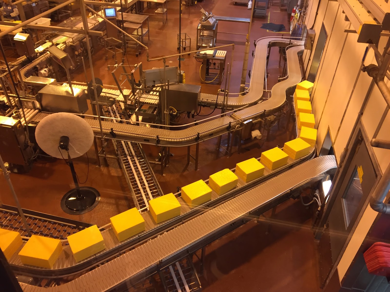 |
| 40 pound blocks of Tillamook Cheese. |
 |
| Fishing boat ready to unload their catch |
 |
| Weighing the tuna. |
We left Garibaldi about noon on Sunday, August 28, in order to catch the flood slack at the Columbia River bar. We arrived at the sea buoy outside the bar about 5:30 p.m. and crossed the bar with no issues. The seas were calm and the sun was out so we had good views of the lighthouse and Coast Guard station at Cape Disappointment. We pulled into the West Mooring Basin in Astoria (56 nm, 8 hours) about 8:00 p.m., tied up at the transient dock and had a delicious seafood dinner on board. We spent Monday touring Astoria including a walk along the river walk, a visit to the Maritime Museum and lunch at a local brewery.
 |
| The lighthouse and north jetty at the Columbia River entrance. |
 |
| Tug and a barge entering the Columbia River. |
 |
| Sealions on the buoy, Columbia River entrance. |
Tuesday, August 30, we cruised up river to Cathlamet and docked at the Elochoman Slough Marina on the Washington side of the river (24 miles, 3.2 hours). This was Patti's first time in Washington State. It was a nice little marina with friendly people and an easy walk into town.
 |
| Patti and Al preparing a gourmet meal in the galley. |
The next morning, we walked into town for breakfast at Maria's before our cruise to Saint Helen's (43 nm, 5.7 hours). It was raining, but the river was busy with large ships and barges. The landscape along both sides of the river is a variety of terrain. We saw deer along the bank along with salmon jumping. We stayed in Saint Helen's for two nights. For excitement, we walked into town, watched a family fish for sturgeon from the dock and watched a cruisers club gather for a rendezvous.
 |
| Being passed by a 600+ feet tanker in the fog. |
 |
| A "bulker" traveling downstream. |
 |
| A 5 foot sturgeon being released. |
 |
| Al working the stern lines. |
 |
| Patti working the bow line. |
 |
| Sunrise, Saint Helens, OR. |
 |
| Sunset, Saint Helens, OR. |
On Friday, September 2, we left Saint Helens for the last leg of Al and Patti's cruise. We arrived in North Portland, Tomahawk Bay Marina (19 nm, 3.3 hours) about 1:30 p.m. just in time for a rain storm. We Ubered downtown to pick up a rental car then unlaxed and had dinner on the boat. Saturday morning we drove to Multnomah Falls, toured the Bonneville Dam and had lunch in Hood River. After a simple supper on board, we took Al and Patti to the airport for a red-eye flight back to Boston.
Dave and I spent the weekend in Portland running errands, exploring some of the local restaurants and hiking in Washington Park.
 |
| Multnomah Falls |
 |
| The fish ladder at the Bonneville Dam. |
 |
| A tug and barge getting ready to lock up at Bonneville Dam Lock. |
Dave and I spent the weekend in Portland running errands, exploring some of the local restaurants and hiking in Washington Park.
 |
| Hoyt Arboretum sign in Washington Park, Portland, OR. |
Tuesday, September 6, we voyaged from Portland to Cascade Locks (35 nm, 6.6 hours) and through our first lock on the Columbia River. We hit a few areas of high current, up to 3.5 kts, which knocked our speed down to 3.5 kts, before getting to the Bonneville Lock. We called the lock master to request a lock up and then waited about 15 minutes before we got the green light to enter. We tied up, let the lock master know we were secured and the gates closed behind us. The lock raises boats from about 8.2 feet mean sea level (MSL) to 72 feet MSL or about 64 feet. About 3 miles upstream from the lock we pulled into the marina at Cascade Locks. The marina is set along the river in a nice park like setting. Cascade Locks is the homeport for the paddle wheeler "Columbia Gorge" and the crew came down to the marina to welcome us after we got tied up. For supper we walked over to the Thunder Island Brewing Company.
 |
| Approaching the Bonneville Dam Lock. |
 |
| Entering the lock after getting the green light from the lock master. |
 |
| The Bonneville Lock gates closing behind us. |
 |
| The gates about halfway up the lift. |
 |
| Exiting the Bonneville Lock. |
 |
| The Bonneville Dam Power Plant. |
There is a lot of history associated with Cascade Locks. Some of the first locks along the Columbia River were built here in the late 1800's. This was an area with some of the roughest rapids along the river and since it was inside the Columbia River Gorge, the portage around was very difficult. It took them over 20 years to finally complete the construction of the locks. You can read some of the history here http://www.cascadelocks.net/about-cascade-locks/cascade-locks-history/. This area is also the home of the Bridge of the Gods, a natural rock formation that crossed the river in this area up until the mid-1700s and the modern, man-made Bridge of the Gods https://en.wikipedia.org/wiki/Bridge_of_the_Gods_(land_bridge). The Bridge of the Gods is also part of the Pacific Crest Trail and is the lowest elevation point on the trail. https://www.pcta.org/wild/hike-from-wild/bridge-of-the-gods-and-the-eagle-creek-pct-alternate-route-oregon/. There were a lot of hikers in town as evidenced by their backpacks. We talked to one hiker who had started the trail at the southern end near the Mexican border and who was hoping to reach the end, near the Canadian border by the end of October. We bought some fresh King salmon, net caught by the local Native Americans, and grilled it for supper Wednesday night.
 |
| The paddle wheeler "Columbia Gorge" |
 |
| The modern Bridge of the Gods |
 |
| The original lock at Cascade Locks |
 |
| Native American fishing platforms at Cascade Locks. |
On Thursday, September 8th, we cruised from Cascade Locks to Hood River (18 nm, 2.9 hours). Hood River is famous for its wind sports and we spent some time along the river front watching the people windsurf and kite surf. We wandered into town Thursday afternoon for some wine tasting and had supper down near the river. Friday, Becky, the wife of one of Dave's friends, took us out to a local winery for lunch, took us to a fruit stand where we bought apples, pears and plums and took us for a tour of the orchards and the surrounding area. The sun was out and we had a great view of Mt. Hood and Mt. Adams.
 |
| View of the Washington side of the Columbia River Gorge |
 |
| Kite surfers, Hood River. |
 |
| Kite surfer at the end of the day, Hood River. |
 |
| Mt. Hood |
Saturday, September 10, we cruised upriver to The Dalles (18 nm, 2.9 hours). We toured a local winery and had supper in town at the Baldwin Saloon. We spend Sunday doing some boat chores and planning our next few days of cruising along with a walk into town to get a few provisions. The landscape between Hood River and The Dalles changes dramatically as the landscape gets drier and the trees thin out. Rainfall statistics for Oregon show that Astoria, near the Pacific coast gets an average of 67 inches of rain per year, Portland gets 43 inches, Hood River gets 31 inches, and The Dalles gets 15 inches.
 |
| Boats fishing for salmon between Hood River and The Dalles. |
 |
| Landscape along the river between Hood River and The Dalles. |
 |
| From the river, looking towards The Dalles downtown with Mt. Hood in the background. |
Monday, September 12, was one of our busiest cruising days on the river, with two locks and a railroad bridge. The first lock (about a 90 foot elevation change) at The Dalles Dam was about 3 miles upriver from The Dalles marina. Another 8 miles upriver is the Celilo Railroad Bridge. This bridge is normally open so that river traffic can go under it, but it was closed so we had to radio the bridge operator to get him to lift it. The second lock of the day was at the John Day Dam, a lift of 105 feet, the highest on the river. We locked up it around noon and from there it was a relatively easy cruise into the Arlington Marina (45 miles, 8.5 hours). We walked into town and had supper at the local deli/BBQ restaurant.
 |
| Approaching The Dalles Lock |
 |
| Entering The Dalles lock after receiving the green light. |
 |
| The gates of The Dalles lock closed behind us. |
 |
| The paddle wheeler Queen of the West waiting to enter The Dalles Lock as we exit. |
 |
| Entering the John Day Lock. The downstream gate is a guillotine style. |
 |
| The lock gate closing behind us. |
 |
| The upstream gate as we lock up. |
September 13th, we cruised from Arlington to Boardman (24 nm, 3.6 hours). It was an easy cruise with calm waters and no wind. We arrived around lunch time and walked into town to eat at the local Mexican restaurant. Today we cruised from Boardman to Umatilla (18 nm, 3.1 hours). Another easy cruise although we hit some current as we got closer to the dam. Tomorrow we start by locking thru the McNary Dam, the last dam on the Columbia, and then cruising into the Tri-Cities of Washington (Kennewick, Pasco and Richland).
 |
| Sunset at Boardman Marina. |


